We are excited to introduce the *beta version* of Tectonic Explorer, our newest Earth system model, developed by our GEODE project. Tectonic Explorer features a complex system of interacting tectonic plates around an entire planet — in this case a simplified, Earth-like planet. For the first time in K-12 education, students will be able to observe plate interactions on a global scale, allowing them to see the interplay between convergent, divergent, and transform boundaries.
Plate tectonic visualizations in K-12 education have typically been static representations of boundaries on Earth, block diagrams of individual boundaries, or simple animations of individual boundary types. However, being able to witness plate interactions on a global scale and engaging students in thinking about many plate boundaries and what is happening along all sides of each plate is both powerful and empowering.
The global perspective encourages:
- Connecting what is happening on Earth’s surface to what is happening at various depths
- Considering what is happening in one location on Earth and how it might affect what is happening in a different location
- Thinking about long time scales
To be clear: Tectonic Explorer does NOT model Earth exactly. This is important for two reasons. First, Earth is astonishingly complex, and trying to model Earth’s precise evolution would be misguided in the goal of helping students to understand whole-planet plate interactions. Second, using Earth as a model limits the interactivity — Earth simulations would have to result in the Earth that we have today with predetermined outcomes that would inhibit student exploration.
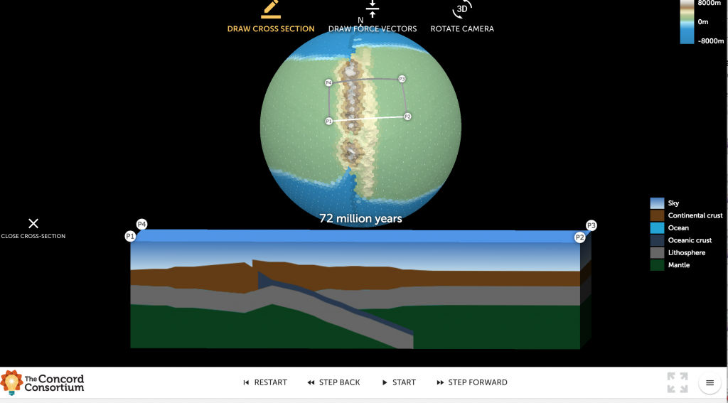 View a cross-section of a plate boundary in Tectonic Explorer*.
Our goal is to give students the opportunity to experiment with a model planet and gain insights about how plate interactions change Earth’s surface over time. This is a very different goal than modeling exactly what happened to, say, the East Coast of North America over 4.5 billion years. Tectonic Explorer models the interactions of plates, based on our understanding of Earth, and represents emergent phenomena that result from these interactions, such as subduction, orogeny, volcanic activity, and island formation.
We have been testing this model (and associated curriculum) in several middle and high school Earth science classrooms this spring. Tectonic Explorer is embedded in a curricular module along with Seismic Explorer, a data model that shows earthquakes, volcanic eruptions, and plate boundary data on Earth. We are excited to learn how students make sense of these visualizations and to get feedback from teachers who are implementing these materials.
We’re looking for teachers and scientists interested in trying Tectonic Explorer and giving us feedback. If you’re interested in using this model, please complete this survey.
*Copyright © 2018 The Concord Consortium. All rights reserved. The software is licensed under the MIT license. The content is licensed under a Creative Commons Attribution 4.0 International License. Please provide attribution to the Concord Consortium and the URL http://concord.org.
One thought on “Learn plate tectonics with an Earth-like model: Introducing Tectonic Explorer”
Comments are closed.
Hello, I only recently learned about this platform. I think it is very helpful for geography teaching in middle school. Thanks to the staff of the team. In addition, I did not find the installation package of Tectonic Explorer on the website. Please install this software. Could the installation package be obtained?