All volcanic eruptions are dangerous. Some are more dangerous than others.
Volcanic eruptions range from slow, relatively gentle flows of lava to explosive eruptions of gases, ash, and rock. Our Visualizing Geohazards and Risk with Code project (GeoCode) challenges students to model tephra volcanic eruptions (tephra refers to all particles ejected explosively from a volcano, regardless of size, shape, or composition), and to consider the hazards and risks related to these eruptions. At the same time the Taal Volcano began erupting, our first cohort of GeoCode teachers was piloting our classroom resources, and students witnessed a real-world reason for studying volcanic eruptions and predicting potential hazards.
Volcanic eruptions are more dangerous when they happen in populated areas. The Taal Volcano in the Philippines began as a large eruption on January 12, 2020. The Philippines government issued a warning alert level of 4 (the maximum is 5), indicating that a more hazardous eruption could happen within hours or days. This is the second-most-active volcano in the Philippines, an area that was formed by volcanoes as one plate subducts beneath another (Figure 1).
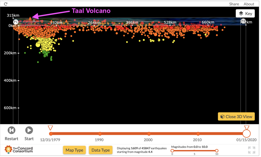
Figure 1. This cross-section view of Seismic Explorer shows earthquake depths near the Taal Volcano. Note the pattern of deepening earthquakes on the western side of the cross-section. The Sunda plate is subducting beneath the Philippine plate, causing a sloped pattern of earthquakes.
Figure 2 shows the locations of Taal Volcano and Mt. Pinatubo, which exploded in 1991, producing the second-largest eruption of the 20th century.
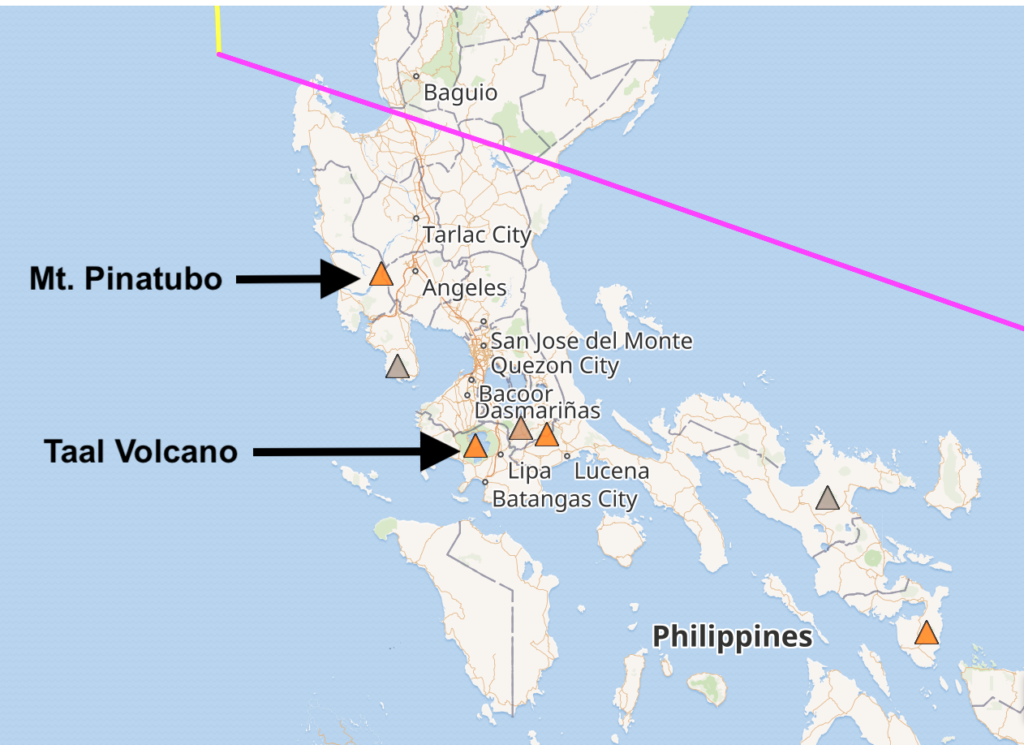
Figure 2. Screenshot from Seismic Explorer, showing the locations of Taal Volcano and Mt. Pinatubo in the Philippines.
The Taal Volcano is one of sixteen volcanoes identified by the International Association of Volcanology and Chemistry of the Earth’s Interior (IAVCEI) as having a history of large, destructive eruptions and being close to populated areas. In North America there are four such volcanoes – Mt. Rainier in Washington state, Volcán de Colima in Mexico, Santa María in Guatemala, and Mauna Loa on Hawai’i. These volcanoes are closely monitored for activity so that people living near the volcanoes can be warned to evacuate before a potentially deadly eruption. The Philippine government ordered a mandatory evacuation for everyone within 14 kilometers of the volcano.
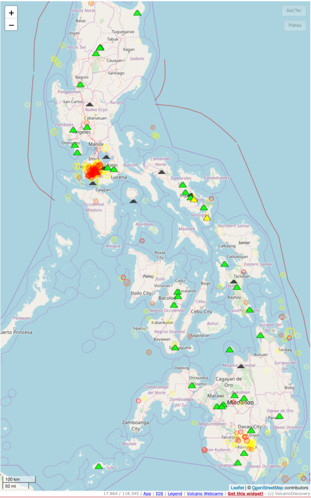
How do scientists monitor volcanoes to provide warnings? First, they continuously measure the seismic activity near these volcanoes. The Taal Volcano area started experiencing swarms of small earthquakes in December 2019. This map from Volcano Discovery shows all earthquakes in the Philippines from January 1, 2020, to January 15, 2020 (Figure 3). Note the large cluster of earthquakes around the Taal Volcano. Most of these earthquakes were small, below magnitude 4.0.
![]()
Figure 3. Map from Volcano Discovery, showing all earthquakes in the Philippines from January 1, 2020, to January 15, 2020.
This Seismic Explorer model is zoomed in to the Philippines and shows the locations of active volcanoes. Use the Start button to see the earthquakes that happened between December 1, 2019, and today. Note that Seismic Explorer only shows earthquakes with magnitudes greater than 4.0.
Scientists also monitor volcano activity by observing the movement of materials below the volcano. Before an eruption, magma moves up into the volcano. Scientists can measure where and how much magma is moving by using tiltmeters and GPS receivers. Tiltmeters measure the deformation, or tilt, of the land near the volcano. GPS receivers allow scientists to see how the location (East/West/North/South and elevation) of the receiver changes over time. Together, these tools can measure very small changes in the elevation of the land, allowing scientists to “see” how magma, gas, and other fluids are moving around under a volcano. Since 2016, the elevation of land around Taal had been decreasing, but in January 2019 the ground began to rise.
Additionally, scientists monitor the mixture of gases emitted by active volcanoes. The gas released from a volcano can increase or change before eruptions. Scientists continually measure the gases emitted by volcanoes in order to detect changes that may signal eruptions.
Finally, because the Taal Volcano sits within a larger crater lake, scientists measure the temperature and chemistry of the water. Water temperature increases as magma moves towards the surface, and the chemistry changes as gases emitted by the volcano are dissolved into the water.
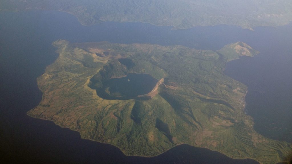
Aerial photo of Taal Volcano. Photo credit: TheCoffee (Mike Gonzalez), Own work, CC BY-SA 3.0
The Taal Volcano poses an additional hazard to people living in the area. Communities near the crater are at risk of being hit by volcanic bombs (rock fragments that range in size from centimeters to meters!) that are ejected as projectiles and fly through the atmosphere. If the volcanic activity is high, large debris from the volcano can fall in the water, displacing the water and causing a “volcanic tsunami” that pushes up walls of water along the edges of the crater lake. Rapid deformation of the crater below the lake surface can also push up the water into a tsunami-like wave.
Almost a year after all the activity described above began to ramp up, the changes started to escalate with a notable earthquake swarm (over 500 earthquakes in a few days), release of gases, and changes in ground elevation. Scientists were certain that the volcano was going to erupt.
Although living near a volcano can be dangerous, national and international scientific agencies are continuously monitoring volcanic activity in order to alert communities to take action before an eruption becomes life-threatening. The Volcano Hazards Program of the United States Geological Survey (USGS) monitors all active volcanoes in the U.S. And the Smithsonian Institution National Museum of Natural History Global Volcanism Program catalogs volcanic eruptions worldwide.
Explore the formation of volcanoes
You can explore how the Taal Volcano and others in the Philippines formed with Tectonic Explorer, the dynamic plate tectonics model used in our Plate Tectonics module. We have recently added a new feature to the model to show where volcanic eruptions and earthquakes occur along plate boundaries. This helps students make connections between Seismic Explorer, which shows only eruption and earthquake data, and the plate movements they can see in Tectonic Explorer.
The cross-section in the model shows that a volcanic island forms when one plate subducts beneath another. A sampling of earthquake locations are indicated by the colored circles; the colors match the colors in Seismic Explorer and show the varying depths of the quakes. Active volcanic eruptions are displayed with orange triangles.
(Note that the time scales of earthquakes and volcanic eruptions are very different from the time scales of plate movement. It’s important to remind students that these are but a sampling of the earthquakes and volcanic eruptions that happen as plates move.)
Figure 4. Tectonic Explorer. The cross-section shows that a volcanic island forms when one plate subducts beneath another.
If you would like to receive updates when new Earth science materials are released or when new research opportunities are available, sign up now!