Stephanie Seevers is an Earth science teacher in Colorado and a consultant on the TecRocks project.
I was talking to my 9th grade Earth and Space Science students recently about why they think so many people lack a solid understanding of our planet and its history. We brainstormed ideas, and while several theories sounded valid, one stood out to me as a real possibility: most people don’t really understand how we gather information about our planet.
The Earth is too large and too old for us to fully comprehend with our five senses; we need to employ more complex methods and piece together many lines of evidence to develop our knowledge of Earth and its processes. And students must be part of the sensemaking process. Telling them scientific facts doesn’t work (nor should it).
In my science classes, that’s exactly what I strive to impart: not just facts about the planet, but how we know. How do we investigate planet-sized and deep-time phenomena?
We typically teach today’s students about plate tectonics as if it’s a foregone conclusion that these are the processes at work on Earth, but that isn’t really the case. The theory of plate tectonics is relatively new, and some of the details are still being worked out.
A century ago, humans didn’t know how old our planet was or very much at all about what was happening beneath its surface. Most people back then laughed at the suggestion that the continents are moving slowly across the globe. Thanks to evidence collected throughout the 20th century, we now understand the Earth much better and have developed a comprehensive theory about plate motion that explains how past and present processes have shaped Earth’s continents and oceans.
To help students begin to understand plate tectonics, the TecRocks project has developed a new activity called Investigating Seafloor Spreading. This one-day activity allows students to use a simulation along with real-world data to investigate structures and rock ages on the seafloor and to connect that data to the theory of seafloor spreading.
Throughout the activity, students develop explanations using evidence about processes taking place on the seafloor and then fit their explanations into a larger understanding of plate tectonics. Like the earlier scientists who used advanced technologies to gather new data about our planet, students will also discover the secrets of seafloor spreading.
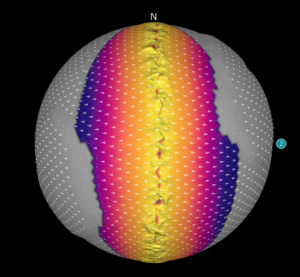
TecRocks Explorer reveals the age of rock on the ocean floor.
Students start by using CODAP to make a graph of depths along a line of latitude in the Atlantic Ocean. They use their graph and map data to “discover” the mid-Atlantic Ridge, a line of volcanoes marking a divergent plate boundary. Next, they sample rock types from the seafloor using the TecRocks Explorer. When students realize that all of the ocean crust is made primarily of the same type of volcanic rock, they will have unearthed another clue to the theory of plate tectonics.
The next line of evidence they pursue is to graph the ages of rocks drilled from along that same line of latitude in the Atlantic. Students will discover that rocks in the oceans are youngest at volcanic seafloor mountain ranges. They go back to the TecRocks Explorer model to simulate plate motion and rock formation and use their investigations to describe the process of seafloor spreading. Finally, to extend their knowledge and skills, students interpret maps of rock ages in the Atlantic and the Pacific to make assertions about the different rates of seafloor spreading on Earth.
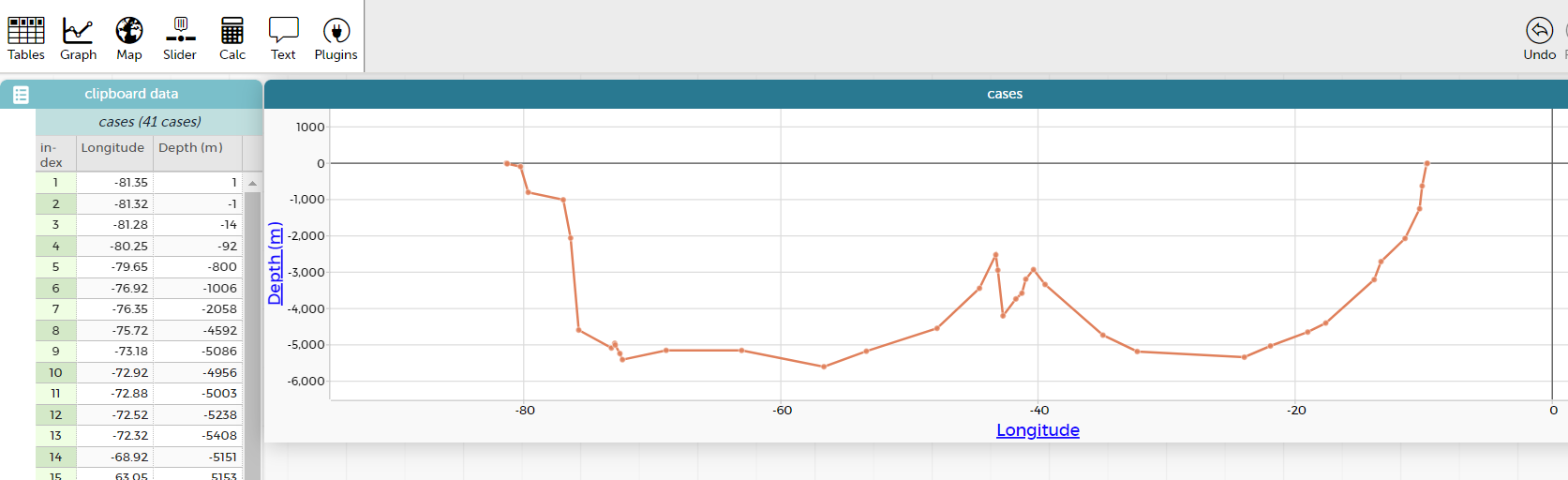
Atlantic bathymetry graph in CODAP.
After completing the module, students should have acquired not only an understanding of the process of seafloor spreading along divergent plate boundaries, but also gained skills in analyzing and interpreting data. Students learn not only about seafloor spreading but also how to investigate Earth phenomena and how scientists are able to theorize about Earth’s past and future.
Investigating Seafloor Spreading
Page 1: What’s under all that water? This introductory page provides background on the advent of sonar as a way for humans to know precise depths in the oceans.
Page 2: Shape of the Atlantic seafloor. Students are given a table with longitudes and depths from Florida to Morocco across the Atlantic at 30° N latitude. They use a simple online graphing tool to create a bathymetric profile across the ocean and see the mid-Atlantic Ridge on the graph and on a map.
Page 3: Rock types on the ocean floor. Students use the TecRocks Explorer model to investigate the types of rocks found in oceanic crust.
Page 4: How to ask a rock for its birthday? Students are given a table with longitudes and rock ages from rocks drilled at sites across the Atlantic at 30° N latitude and graph this data. They analyze the symmetrical pattern of rock ages on the seafloor on either side of the mid-ocean ridge.
Page 5: The making of new ocean crust. Students use the TecRocks Explorer model to simulate the conditions they’ve found by analyzing real-world oceanic data, and piece together an understanding of the processes involved in seafloor spreading.
Page 6: Plate tectonics: A theory emerges. Students link what they’ve seen in the model to a map of the Atlantic Ocean and make connections from their simulation to processes in the real world.
Page 7: Stories rocks can tell. Students add rock ages data from the Pacific Ocean. By comparing two maps, students can reason that the divergent boundary in the Pacific is spreading faster than the one in the Atlantic.