With most California residents living within a 30-minute drive of one of the state’s 500 active fault zones, the threat of earthquakes looms large. Scientists are constantly monitoring seismic activity, conducting risk assessments to determine when and where earthquakes may occur, and predicting the potential impacts to surrounding communities. Our new National Science Foundation-funded YouthQuake project aims to bring this important work to middle school students in an urban California district, so they can engage in authentic science practices traditionally done by geoscientists.
Geoscience is the least diverse field of any STEM discipline, with the fewest Hispanic and African American scientists. California, on the other hand, is the second most diverse state in the U.S.! We hope to begin to address this imbalance by engaging diverse middle school students in the same type of computational geoscience investigations that scientists do and to increase students’ computational geoscience interest and identity.
We are excited to partner with teachers, geoscientists, educational researchers, technology and curriculum developers, a professional development specialist, and a workforce and diversity specialist to design a curriculum for students to explore earthquake hazards, risks, and preparedness in the context of their own communities. Each team member will bring their own expertise and perspective to the co-design and evaluation of the YouthQuake curriculum.
We will develop a four-week curriculum that consists of three units, each taking approximately one week of in-class time, as well as a one-week student independent summative project. The curriculum will include additional out-of-school activities to gather data, for instance by interviewing community members. The units will be situated in the community context as students (1) explore their neighborhood’s likelihood of experiencing a damaging earthquake and related preparedness, (2) investigate GPS data and use computational models of land motion along the faults around their community, and (3) create computational visualizations of earthquake hazard maps. Throughout the curriculum, students will have opportunities to talk with a diverse group of scientists and undergraduate students about their experiences in the field of geoscience.
Models and Visualizations
YouthQuake will build on the GeoCoder platform, which allows students to model natural hazards based on large datasets collected by organizations such as the USGS. The GeoCoder uses block coding to simplify the syntax typically associated with programming, using shapes to give clues on how programming ideas are combined and algorithms are formed. In addition to traditional blocks such as loop and data blocks, new blocks were developed for the GeoCoder that are specifically designed to enable authentic investigations of geoscientific topics such as “Filter GPS stations” and “Display GPS velocity vectors.”
Students write block code and can see their program output on an integrated map. Students can modify their code, observe the resulting visualizations, and interpret the computational outputs generated on the map. YouthQuake will add location-specific maps and computation blocks needed to carry out earthquake-centered investigations in the curriculum.
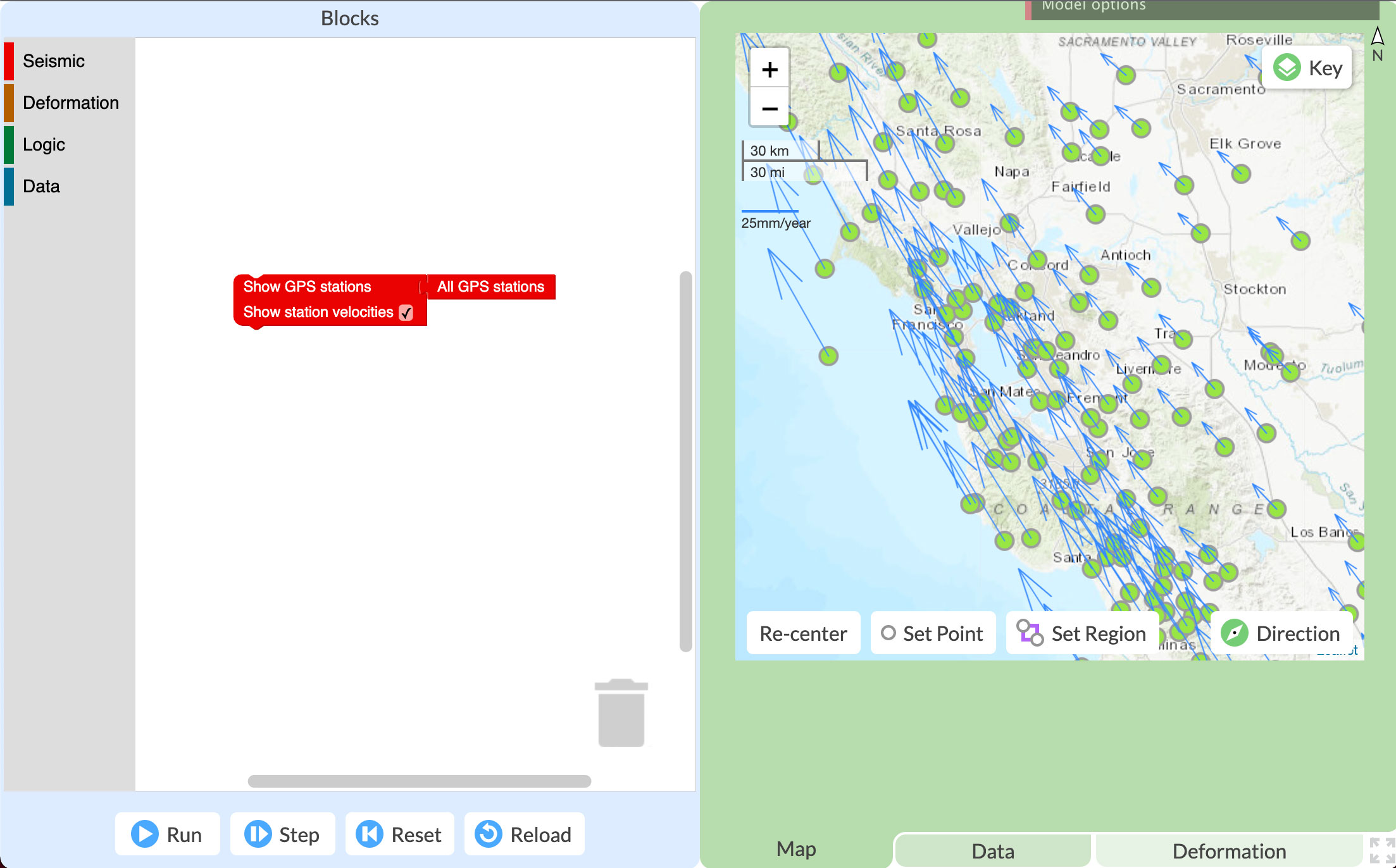
The GeoCoder programming space on the left and GPS locations in California, on the right.
The YouthQuake curriculum will also embed our Seismic Explorer visualization, which displays real-world earthquake, volcanic eruption, and plate motion data. Students use Seismic Explorer to display data at any time point or any duration from 1980 to the present, zoom in and out of the visualized data, and look for earthquake, volcanic eruption, and landform patterns in relation to plate locations on Earth’s surface. By examining cross-sections, students can also investigate earthquake depth patterns along faults.
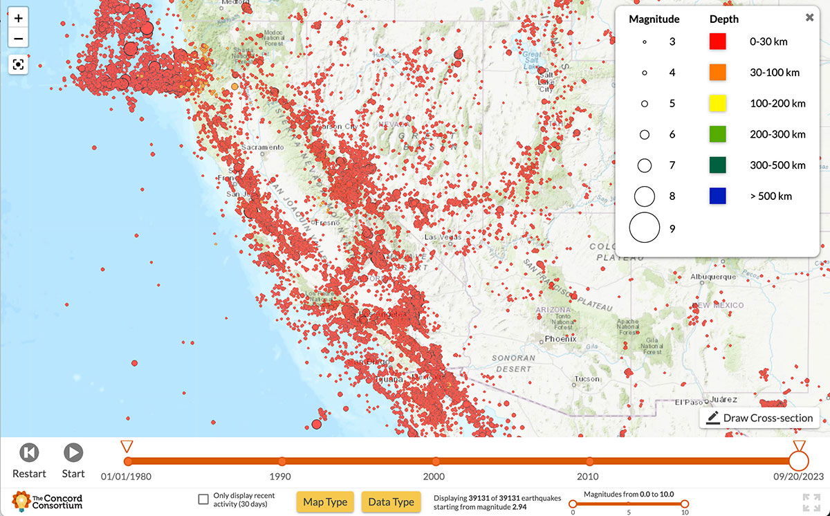
The Seismic Explorer showing the number of earthquakes that occurred in California between 1980 and the present.
Research Goals
The YouthQuake project will contribute to the Earth science education community’s understanding of how engaging students with computational activities and prioritizing their knowledge, personal experiences, and community values can broaden the participation of diverse students in geoscience. We will explore the following research questions:
- What types and levels of computational reasoning do students elicit during the YouthQuake curriculum? What computational reasoning do they learn as a result of the curriculum in the context of local seismic risk assessment?
- Do students’ computational geoscience identities change before and after they use the YouthQuake curriculum? What factors are responsible for changes in students’ computational geoscience identities, including demographic variables, students’ personal meaning attributed to YouthQuake activities, and their learning gains in computational reasoning?
- What aspects of the computational geoscience practices enhance or impede Hispanic and African American students’ development of epistemic agency?
- How do students identify and address their community needs when they assess community risks, develop methods for communicating risks to the community, and develop community-based solutions?