Monday’s Lesson: All About Basalt
There are over 4,000 types of minerals on Earth. These minerals combine in various amounts to form thousands of different rock types. Look at a geologic map of the United States and you’ll see a kaleidoscope of colorful streaks, each representing a unique rock type. But look at a geologic map of the ocean and you’ll see just one rock: basalt. It’s true. This singular igneous rock forms the surface layer of every ocean basin on Earth, covering about 60% of the entire globe. Why is this one rock type so abundant on the ocean floor? And how did it get there?
Our TecRocks Explorer allows students to investigate such questions and uncover the connection between rock formations and the environments and processes that generate them. With this dynamic, Earth-like model, students can set up plate tectonic simulations, explore emergent phenomena, and develop explanations about the distribution and types of rocks forming in various tectonic environments.
1 Open TecRocks Explorer
Go to https://tectonic-explorer.concord.org/index.html?rocks=true
- Select layout of the planet. Select the number plates for your planet.
- Draw continents. Click and drag your cursor to draw continents, which appear as green blobs. If you want continents around the planet, click Rotate Planet, then click and hold the mouse to move the planet. Click the Next button.
- Assign boundary types. Hover over the boundary between plates (the pink lines), then click to select how the plates move in relation to each other. They can either collide (converge) or diverge. For this investigation, set at least one boundary type to Divergent. Click the Next button.
- Order plates. Finally, choose the density of each plate in relation to each other. Click Finish when you are done with your planet setup.
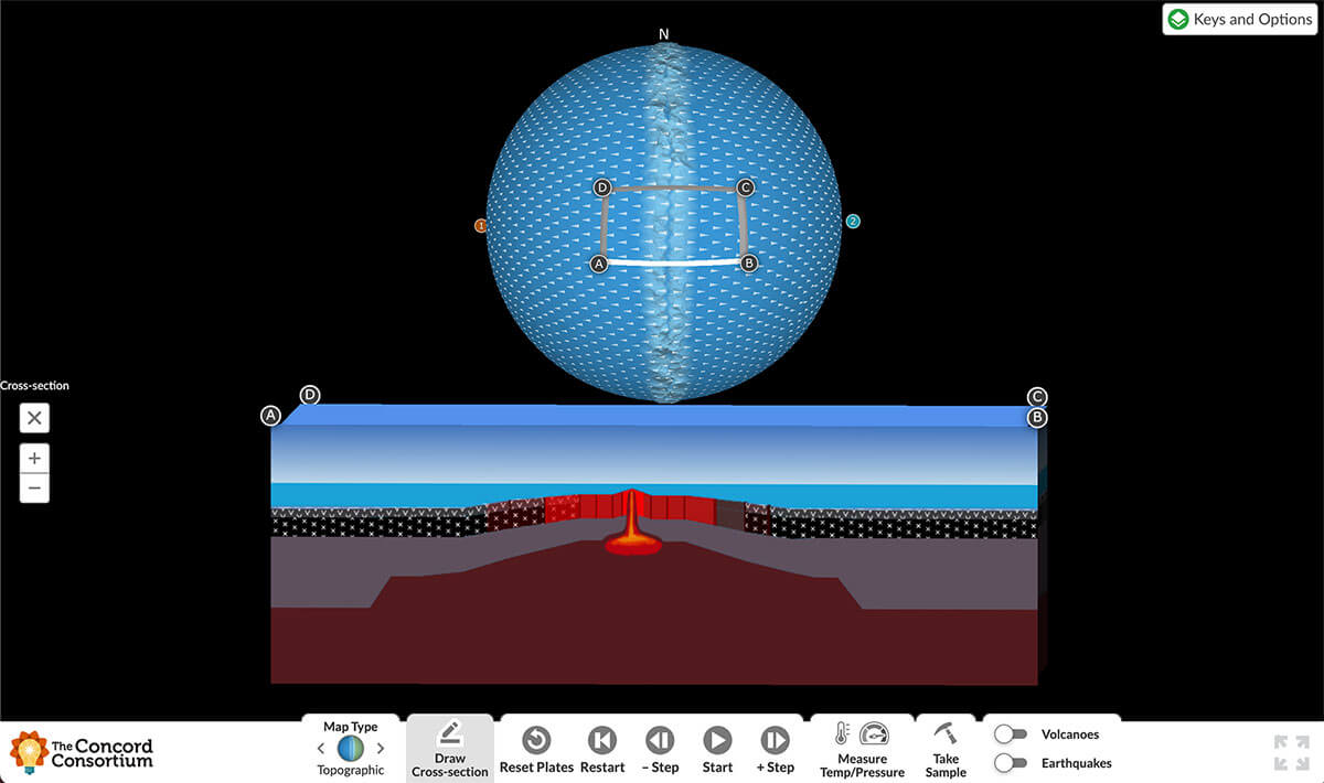
2 Draw a cross-section
In the toolbar below the model, click the Draw Cross-section button. Your cursor changes to a cross. Click and drag from one side of the divergent boundary to the other. The cross-sectional view cuts a vertical slice through the Earth-like planet so you can look at it from the side and see what’s going on below the surface of the Earth (Figure 1). The different colors and patterns each represent a different type of rock. Press Start to run the model. Watch as the plates on either side of the divergent boundary begin to move away from each other.

3 Dig deeper (literally)
Watch the cross-section view while running the model. Notice that magma moves at the divergent boundary, upwelling out of the mantle and onto the surface of the Earth, where it quickly solidifies and hardens into rock due to the cold temperatures at the bottom of the ocean.
To find out what types of rock form through this process, use the Take Sample tool. Click the various rock layers, and refer to the key to learn more about the different rock types.
4 Discuss
Using a map of plate boundaries around the Earth, point out that all oceans have divergent boundaries running through them. Ask students how this plate movement explains why basalt covers the entire ocean floor. How does this tectonic environment create the conditions for basalt to form? Where would you expect to find the oldest basalt in the ocean?
Looking for more?
Created by our TecRocks project, the TecRocks Explorer is embedded in a weeklong curriculum unit for middle and high school classes. Students use the TecRocks Explorer and data visualizations to reason about tectonic environments, rock-forming processes, and rock types.
Christopher Lore (clore@concord.org) is a research assistant.
This material is based upon work supported by the National Science Foundation under grant DRL-2006144. Any opinions, findings, and conclusions or recommendations expressed in this material are those of the author(s) and do not necessarily reflect the views of the National Science Foundation.