Across the Earth, rock is being created, destroyed, and transformed all the time. If you were to witness a volcanic eruption up close, you would see the birth of new rock. While such an eruption results in a dramatic display of Earth’s power, many rock-forming processes are invisible as they take place deep beneath Earth’s surface and over an inconceivable amount of time.
To help reveal the mysteries that cannot be explained with the traditional rock cycle diagram, our National Science Foundation-funded TecRocks project has developed the Rocks & Tectonics module, which is now freely available to the public.
The online five-activity module, designed for middle and high school Earth science classrooms, scaffolds students’ ability to make connections between rock types, tectonic environments, and the processes and conditions.
In activity 1, Earth: It’s rocky out there!, students are challenged to shift their thinking about rocks from objects they hold to the vast, thick layers that make up Earth’s surface. In activity 2, Eruptions everywhere, students use two new embedded interactives to examine locations where new rocks form on Earth and link those rocks to the tectonic processes that created them. In activity 3, Recipes for rock, students investigate the different types of igneous rock that form as magma rises to the surface along convergent boundaries. In activity 4, Rock transformation, students discover that changes in pressure, temperature, or both along active tectonic boundaries can transform rock from one type to another. Finally, in activity 5, From sediment to rock, students investigate erosion and deposition, and explore how sediments in passive tectonic environments become rock over long periods.


Interactive embedded tools designed for the Rocks & Tectonics module. Left: The TecRocks Explorer shows rock formation and allows students to sample rocks to learn more about their characteristics. Right: Students explore the real-world distribution of rock types with the Earth Rocks 3D Map.
To engage students in learning about the formation—and transformation—of different types of rock created under a variety of tectonic conditions, the Rocks & Tectonics module employs two unique interactives. First, to reveal the rock-forming action that exists at the boundaries of tectonic plates, we developed an interactive model called the TecRocks Explorer. The TecRocks Explorer builds upon the success of the Tectonic Explorer in helping students investigate tectonic environments and the rocks that form in these environments. Students can set up an Earth-like planet by adding continents and setting the direction of plate motion. As plates move, the planet’s surface transforms. Students can create a cross-section of any part of the planet to see what’s happening below the surface. In the cross-section view, students can take rock and magma samples, and measure changes in temperature and pressure at various depths.
Using TecRocks Explorer, students can discover previously hidden processes. For example, one investigation in the module focuses on the process of magma rising to the surface through the crust at a convergent boundary. Students observe that magma cools and forms different types of igneous rock as it rises. In another example, shown below, students use the data collection tool to explore the process of metamorphism that occurs when two pieces of continental crust converge. Students place pins at specific locations in the cross-section to collect data (e.g., temperature and pressure) on the rock in that area. The saved data is automatically compiled into a table. Students can look for patterns, such as the increase in metamorphic grade of rocks deeper under the resulting mountain.
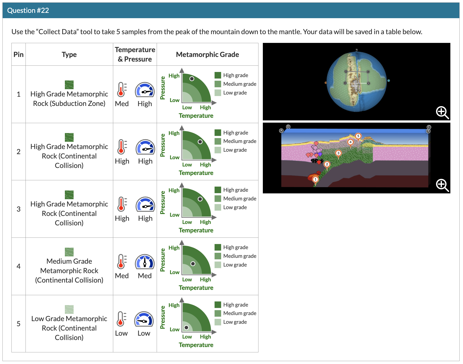
Students collect data on rocks below the surface.
The simplified geologic Earth Rocks 3D Map was developed to help students connect what they’re learning in their experiments with TecRocks Explorer to rock distribution on Earth. This map was specifically designed to coordinate with the TecRocks Explorer so that students can link the rock-forming processes and resulting rocks with tectonic boundaries. In the module, students use this map to identify rocks and land formations at or near plate boundaries. Students use this information as evidence for the tectonic processes that must have existed to form the rocks at certain locations on Earth.
The Rocks & Tectonics module was field tested over the 2022-23 school year by 14 teachers across 12 states. Teachers have told us:
- “I usually don’t teach about the locations of the different rock types, and now I think this is very important to connect the genesis of rock types with plate movement. I will most definitely teach plate tectonics and the rock cycle in a connected fashion as this module does.”
- “I really love both these tools, especially paired with each other. I was searching for both a manipulative plate tectonics model, and simplified geologic maps, and these tools provide both at exactly the level appropriate for all of my students. These tools allow me to teach Earth science with NGSS better than other classroom tools I have had.”
- “My students gained a lot by being able to see the different types of plate boundaries and how they affect the rocks below the surface, especially over time. I think they got some of the basics, such as that temperature and pressure really matter, and the content of igneous rocks determines the type. I think they also understood that depending on how the plates are moving and the density of the plates, different geologic features will result.”
The Rocks & Tectonics module and the two interactive tools are freely available on the STEM Resource Finder. A suite of teacher resources accompany the module, including pre- and post-assessments, a standards alignment, and an interactive Teacher Edition that contains background information, exemplar answers to question prompts, discussion points, and instructions on how to use the TecRocks Explorer and Earth Rocks 3D Map. A class dashboard also allows you to track student progress in real time.