The rock cycle, presented in nearly every Earth science curriculum and textbook, is typically taught in the same way from one classroom to the next. Students are shown an image that summarizes how all rocks are related to each other with suggested pathways by which one rock can transform into another rock. A nice, simple diagram with labeled arrows. The problem? Well, there are many. To start, it’s hard to show processes through a static image.
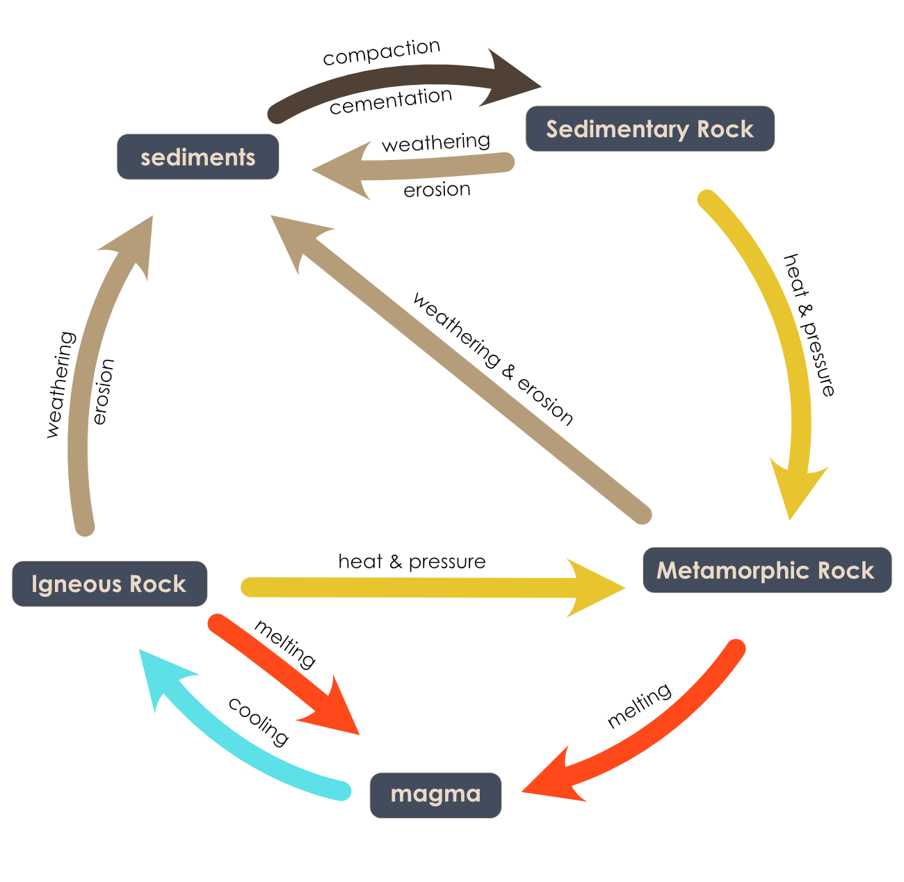
The rock cycle as pictured above is an abstraction. What does this have to do with Earth? Where on Earth can these different rock types be found? What is happening on Earth to cause these rock formations and transformations? Does one rock go through all these transformations?
Furthermore, there is little explanatory power in this static rock cycle. How rocks form and where they are likely to be found is missing.
Now imagine connecting rock formation to the environments and processes that generate them.
Geologists connect both rock formation and rock transformations to the tectonic environments in which they form. In other words, when a geoscientist thinks about the rock cycle, they understand that rock formation is deeply connected to the tectonic plate system. Can we help students do this, too?
As part of our National Science Foundation-funded TecRocks project, students will explore a model that combines the traditional rock cycle with specific tectonic processes.
Our TecRocks model is an idealized, simplified Earth-like model designed to reduce complexity while illuminating multiple rock formation patterns as they relate to tectonic environments. We developed these features as part of our original Tectonic Explorer model, adding rock formation patterns to the existing three-dimensional dynamic tectonic plate system. The new TecRocks version of the model will be embedded into a scaffolded, multi-day online curriculum unit to help students realize that every rock has a geologic story to tell about the environment it formed in.
The goal of the TecRocks model is to allow students to set up a plate tectonic simulation, explore the emergent phenomena, and develop explanations about the distribution and type of rocks forming in various tectonic environments.
For example, rocks that form along a divergent boundary create the oceanic crust—these are igneous rocks. In the model they are the black and dark gray rocks called basalt and gabbro. When you explore the model, you find basalt and gabbro forming from magma rising and solidifying along the divergent boundary.
Rotate the planet and you see a convergent boundary where the basaltic and gabbroic oceanic crust is subducting under the less dense granitic continental (pink) crust. As the oceanic crust subducts into the Earth, it reaches high temperatures, and volatiles from the crust cause the mantle above it to melt, forming the magma that then rises through the continental crust, as depicted by the red diamond shapes. The thicker the crust, the more the magma changes composition as it rises. This is because different minerals crystalize from the melted magma as it cools, which then changes the composition of the remaining magma.
The model shows the rock types forming at different depths. For example, magma that solidifies closest to the mantle is gabbro (dark gray), then diorite (purple), granite (pink with straight line texture), and rhyolite (pink with ^ texture) form as the magma rises nearer to or solidifies on the surface. As the planet evolves over time, students can also quickly see that the igneous rocks—those formed directly by magma rising from deeper in the planet—do not erupt everywhere. They can explore the planet and look for distribution and composition patterns related to the tectonic environments using the TecRocks model.
Similarly, students will be able to investigate where metamorphic and sedimentary rocks appear in the model and how they are a result of the tectonic conditions in which they form.
Through scaffolded activities, guided explorations of different tectonic environments, and the introduction of progressively more complex model features, students will have the opportunity to investigate phenomena such as how sediments from deep in the ocean end up on top of mountains or how magma only rises to the surface in specific locations.
Using a 3D dynamic interactive model based on plate tectonics, our goal is to move learning about rocks beyond simple categorization. If we pay careful attention, rocks can tell us a story about the location and conditions under which they formed.
If you would be interested in piloting this new approach to teaching about rock formation and would like to share your feedback through small focus groups and classroom implementations, please let us know!