We are excited to announce that our GeoCode: Volcanic Hazards module is available for public use! This free two-week curriculum for middle and high school students has been piloted by participating research teachers as part of the National Science-Foundation funded GeoCode project and extensively studied and redesigned based on our research. It is now available to teachers worldwide. The Volcanic Hazards module engages students in modeling tephra fallout from volcanic eruptions and analyzing the risk tephra poses to people and places near the volcano. Tephra is composed of glass fragments produced when magma from a volcano cools very quickly.
Students use a block-based programming tool called GeoCoder to write code to input, iterate, and investigate the effect of environmental variables such as wind speed, wind direction, and Volcanic Explosivity (VEI) on tephra distribution outputs. Students gain an understanding of how each factor influences the location and thickness of tephra fallout.
The recent eruption of the Hunga Tonga volcano on January 15 demonstrates just how devastating a tephra eruption can be for people and their property. Tephra was launched over 20 kilometers into the air – halfway to space – and the eruption cloud grew to be 650 kilometers wide (wide enough to cover the entire state of Florida). The satellite image in Figure 1 shows the spectacular scale of this eruption, one of the largest in the satellite era.
The eruption, which could rank as high as a 5 out of 8 on the VEI scale, came from an underwater volcano and sent towering ocean waves around the Pacific Ocean, causing tsunami warnings to be issued in coastal South Pacific countries. As these waves were sent out, tephra began falling down on the nearby island of Tonga.
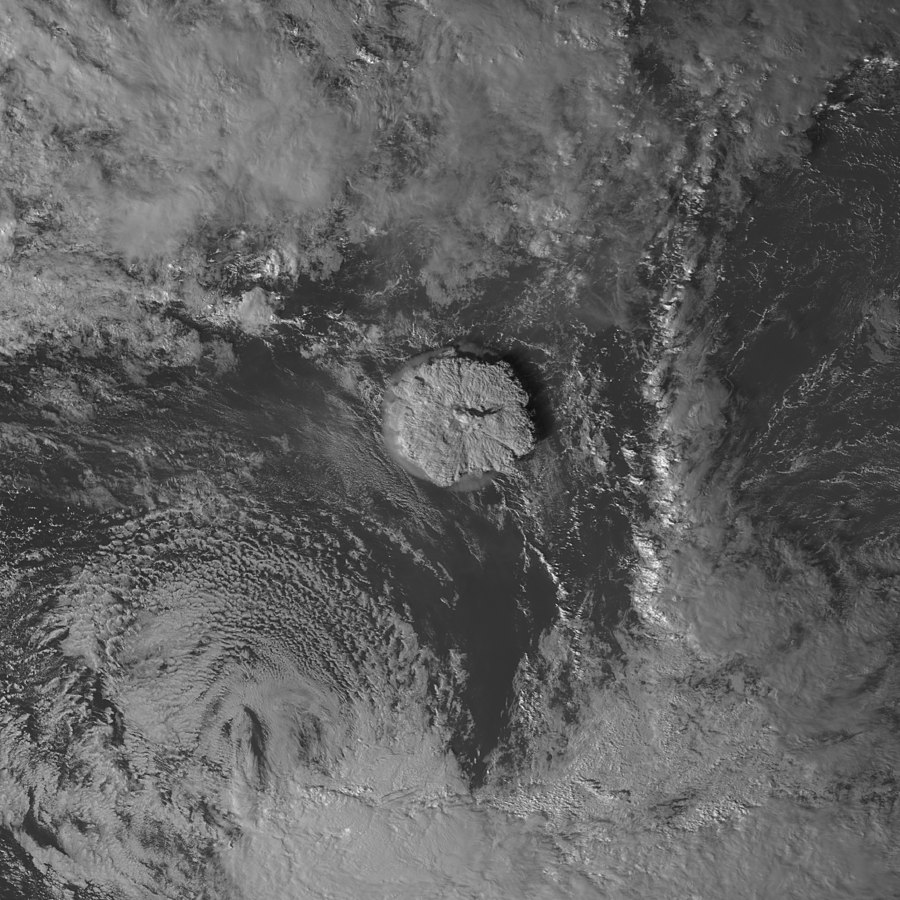
Figure 1. The tephra cloud from the January 2022 Hunga Tonga eruption captured from satellite. Japan Meteorological Agency/NASA SPoRT/Wikipedia Commons licensed under CC-BY-4.0.
Tephra is erupted in all shapes and sizes. It can be microscopic or it can be as large as a car. Volcanologists study the size, composition, and density of tephra produced during volcanic eruptions, including the recent Hunga Tonga volcano, to create and refine mathematical equations that model the distribution of tephra.
Our partner volcanologists at the University of South Florida, led by Dr. Charles Connor, supplied us with their tephra dispersion equations developed through years of research on several different volcanic eruptions. The equations govern the behavior of the GeoCoder model. When students adjust the environmental variables using blocks of code, they are adjusting the input parameters to these complex equations. In other words, students use the same modeling tools in the Volcanic Hazards module as scientists do in real life.
Figure 2 shows tephra from the Hunga Tonga eruption on plants, buildings, and streets in Nomuka, Tonga. Several millimeters of tephra completely covered crops, put stress on rooftops, and created hazardous air quality throughout the islands in the South Pacific. Tephra is one hazard of a volcanic eruption, meaning it has the potential to cause harm to people and their property. Depending on the amount that falls in a certain location, tephra can cause different hazards.
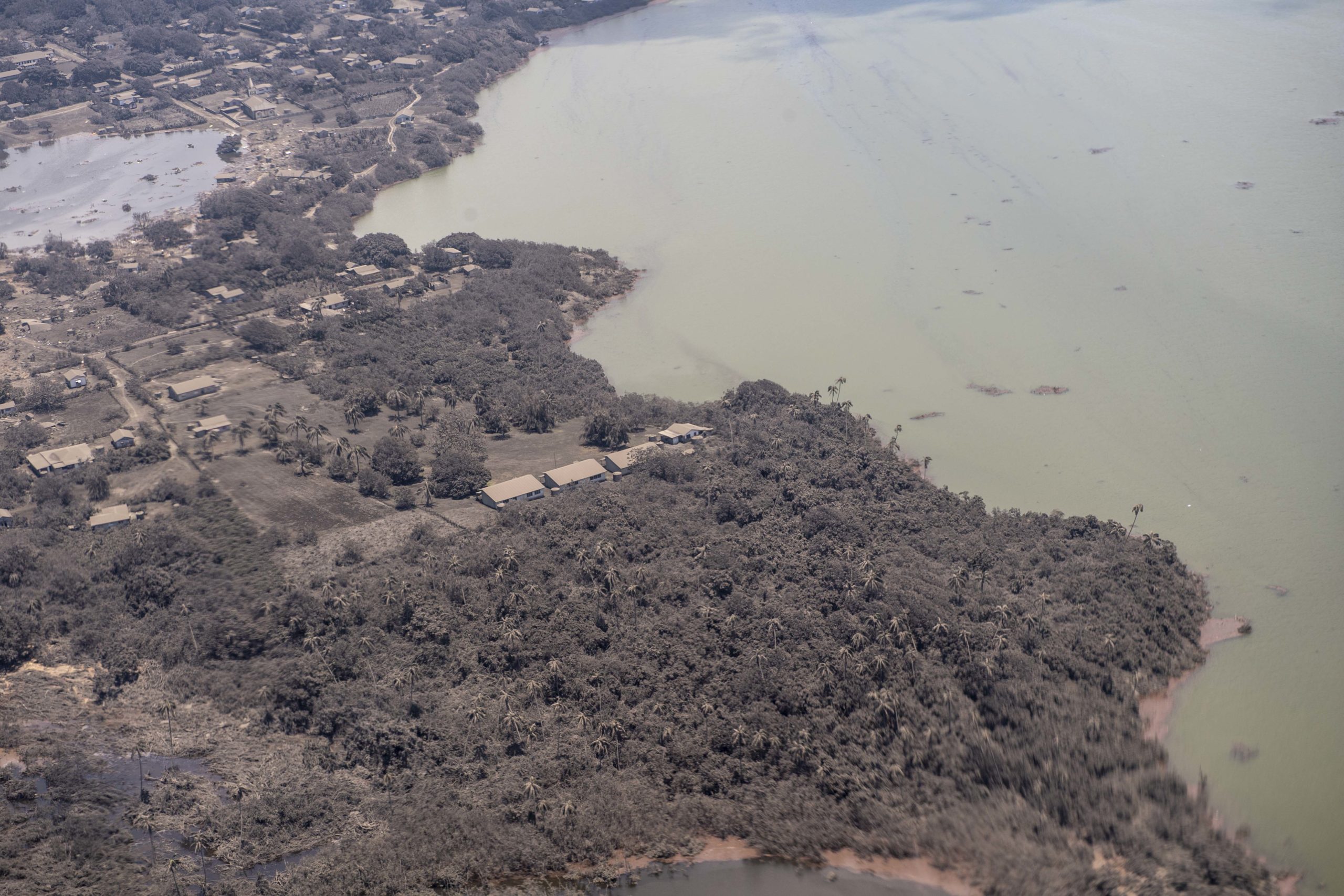
Figure 2. View of Nomuka, Tonga, taken by a Royal New Zealand Air Force P-3K2 Orion during a reconnaissance flight on Monday, January 17, 2022. Copyright New Zealand Defence Force.
Because of its recent history of eruptions, scientists were aware that Hunga Tonga was likely to erupt again. Scientists could monitor the volcano in real time with imagery from satellites orbiting the earth. When Hunga Tonga erupted, the satellites tracked the height, extent, and approximate amount of ash in the tephra cloud. Measurements like this mean scientists can also consider the following: What areas around the volcano are most at risk of experiencing tephra fallout from an eruption? How large will the next eruption be? How likely is it that Tonga will experience several millimeters of tephra fallout? Based on this current and past data, scientists run simulations with wind data, VEI, and many other factors in order to assess the risk and potential impacts of an eruption.
Students using the Volcanic Hazards module can ask similar questions, focusing on the Cerro Negro volcano in Nicaragua (Figure 3). This active cinder cone volcano has erupted 9 times in the past 70 years. Students also have access to 8 years of wind data collected from around Cerro Negro from 2011-2018, amounting to 16,000 data points.
Through exploration of the patterns in wind speed and direction, along with the estimate of how large the next eruption will be, students reason about the likelihood of tephra falling on towns around the volcano. The computational power of the GeoCoder allows them to run experiments with thousands of data points and synthesize the effects of environmental factors to produce a risk assessment. Engagement in this authentic scientific investigation allows students to feel that the work they do is relevant to the world around them today.
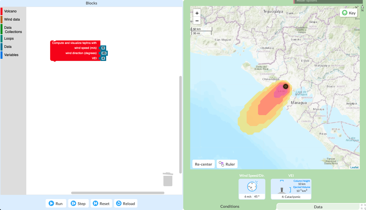
Figure 3. The GeoCoder model. The Program Workspace with block code on the left controls the output visualization on the right.
We invite you to run the GeoCode: Volcanic Hazards module in your classroom. The material comes with pre- and post-tests, teacher support materials, NGSS standards alignment, a code cheatsheet, and much more!