At the end of January I had the opportunity to visit the Big Island of Hawaiʻi to observe the implementation of a middle school Earth science curriculum module called “Pele’s Playground.” The module focuses on using block-based programming of a computer simulation to learn about factors affecting where lava flows and volcanic smog, or “vog,” moves.
Pele’s Playground was developed as part of the National Science Foundation-funded Pelehonuamea Project. Our aim was to create a place-based module featuring Hawai‘i’s volcanoes that seamlessly integrates geoscientific reasoning and computational thinking. We were guided by the Next Generation Science Standards disciplinary core idea ESS3.B, which states: “Mapping the history of natural hazards in a region, combined with an understanding of related geologic forces can help forecast the locations and likelihoods of future events.” We also sought to contextualize it with the lived experiences of the Hawaiian teacher and students who are participating in the project.
I was there to support the implementation and learn how the module was received.
Pele’s Playground
Pele’s Playground includes five activities designed to help students explore the environmental variables that influence where lava and volcanic smog flow after an eruption. Students use the LavaCoder, an online environment that combines a block-based programming tool with a volcanic simulation engine that models volcanic eruptions on the Big Island of Hawai‘i.
Students program parameters in the left window that control the volcano simulation in the right. The module scaffolds students’ content learning and coding skills through increasingly complex investigations. Using various blocks to code how the LavaCoder simulation runs, students are able to 1) place vent locations, 2) select eruption volume, 3) choose lava thickness, and 4) tag locations on the Big Island of Hawai‘i.
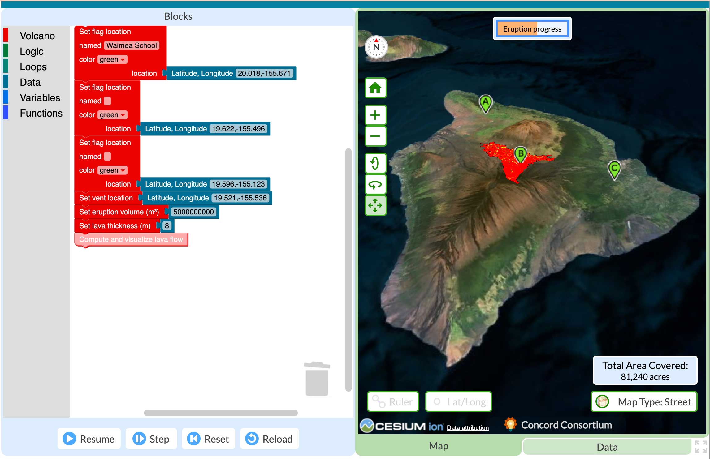
The LavaCoder environment includes blocks on the left and the simulation that displays the results of the code in a visual format on the right.
I was a little nervous about the implementation. New technology is always a tricky business and the LavaCoder had never been stress-tested by more than a few users at a time. But I also knew that the implementation was in good hands—the eighth grade Earth science teacher was well prepared.
Kīlauea volcano
On my first morning in Hawai‘i, I woke up to an email from a volcanologist who lives on the island and who had helped design the simulation.
Kīlauea was erupting.
“If you want to see it,” she wrote, “you should drop everything and go as soon as the higher fountaining starts. These episodes have only been lasting for a few hours at a time, and so you can’t really wait. It has been overflowing a lot this morning, which is one of the main precursors to activity. ”
Kīlauea had been erupting episodically for over a year. Episode 41 had just begun, and I really wanted to see the eruption.
While I know volcanoes are dangerous, as a geologist myself I wanted to see Earth doing something this extraordinary (from a safe distance). Unfortunately, the roads to the volcano were closed, so I didn’t make it.
Of Kīlauea’s recent eruptions, episode 41 was one of the biggest. The lava fountains reached heights of at least 450 m (1475 ft), tephra ranged from the size of peas to the size of footballs, vog spread across the island, and small shards of glass called Pele’s hair were carried by the wind. The conditions made it dangerous to be anywhere in the vicinity of the falling rocks and glass.
Activity one of the curriculum
Two days later, our partner teacher began the module by conducting an oli, a traditional rhythmic chant, about Pele, the Hawaiian goddess of volcanoes and fire. She discussed which words in the chant described eruptions.
The students then all logged into their computers and began the online curriculum. Early in the module students are asked, “What are three things that you and your family have learned about living on a volcano and living with volcanic eruptions?”
After writing their thoughts, they shared their experiences. The recent eruption of Kīlauea came up. Students said:
- “The vog made my throat hurt.”
- “It was raining ash.”
- “Pele’s hair was everywhere.”
As I was taking notes, it occurred to me that my throat had been bothering me as well. I thought it was due to jet lag. But vog was covering the island—as evidenced by the orange tint to the normally very blue sky. My throat was likely irritated by the vog, just like the students had said.
Activity three of the curriculum
At this point, students were deeply immersed in exploring lava flow in the LavaCoder. Wandering around the classroom, I heard students thinking about how to use the code to explore volcanic eruptions and the potential impacts.
- “I wonder how much lava it would take to cover Hawai‘i?”
- “Can we change the amount of lava to whatever we want?”
Upon seeing the modeled movement of lava flow in the simulation, one student said “No, wait! That’s my house!”
This engagement—of students asking questions about their own lived experiences—is exactly what we hoped to see. Students were using LavaCoder to consider both the factors that affect lava flow and how and where eruptions of different magnitude and vent locations might impact the people and the environment.
At the end of the day, the volcanologist emailed again, this time with links to videos and photos that she took while monitoring the eruption, collecting samples, and helping neighbors recover from the eruption’s impact. I shared these photos and videos with the teacher to connect the recent eruption to the module.
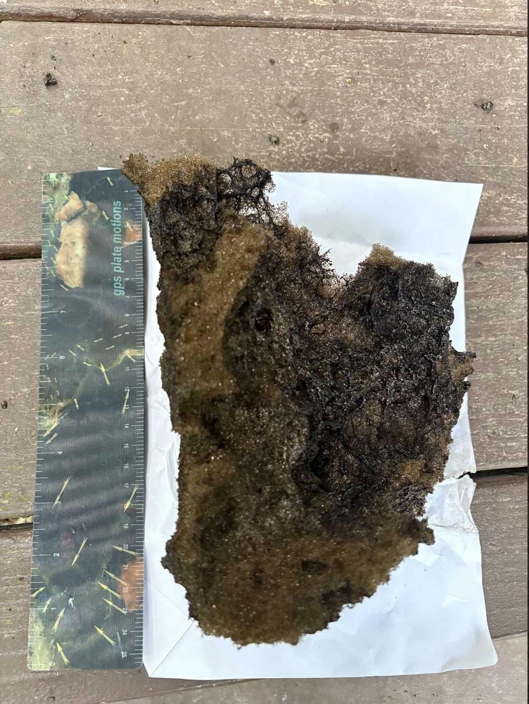
One piece of tephra nearly eight inches long that fell near Dr. Gallant’s home. Photo by Dr. Lis Gallant.
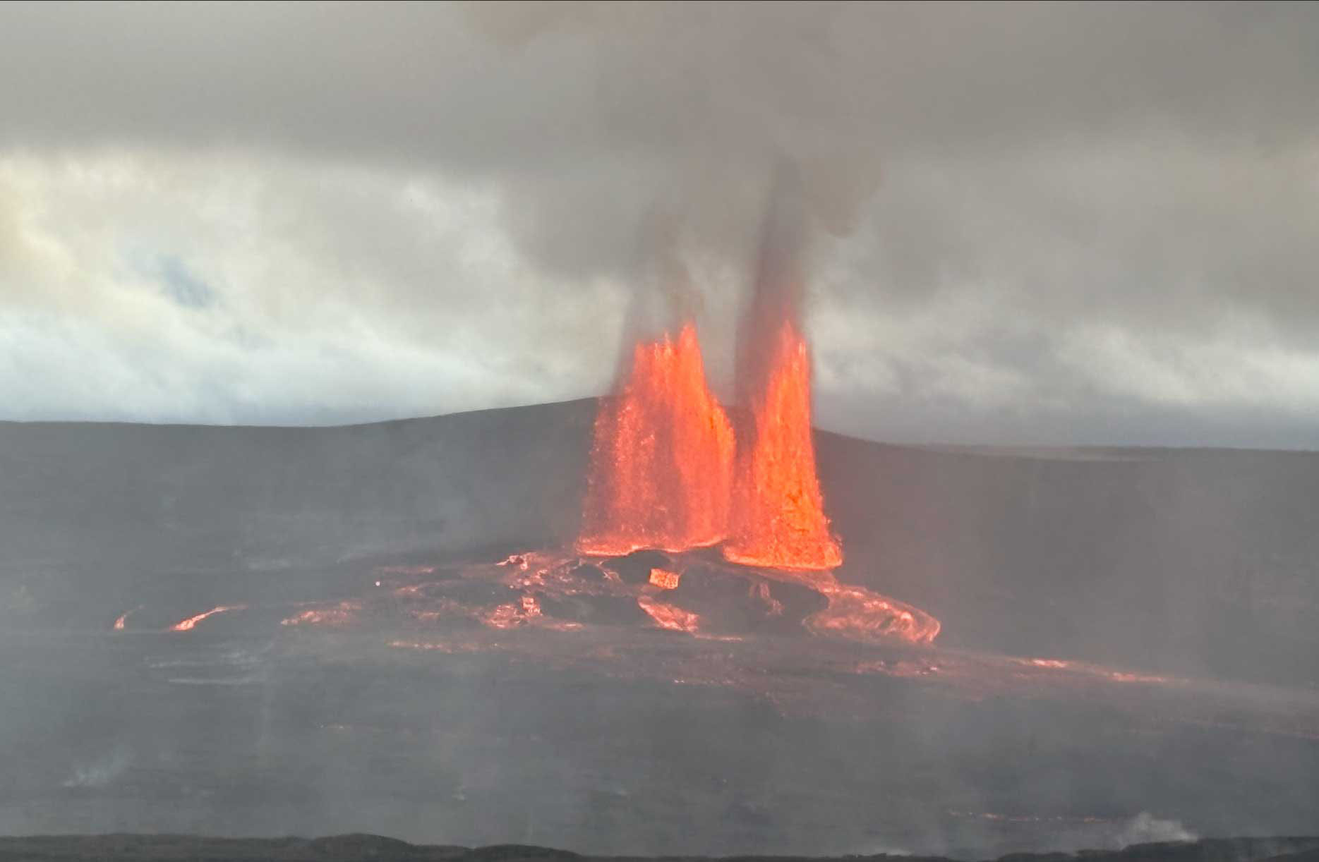
Episode 41 lava fountain and lava flow as seen from the rim. Photo by Dr. Lis Gallant.
Activity five of the curriculum
In activity five of the curriculum, students explore the environmental factors that control where vog travels. By this point, students were familiar with the LavaCoder. They were asking questions related to both coding and geoscience as they conducted their own simulation-based inquiry, including, for example, investigating the effects of winds. What they discovered through the simulation was that when the trade winds blow, their school will likely be impacted. Kona winds, on the other hand, will likely affect a town on the opposite side of the island.
Seeing the volcano at last
I finally made it to the rim of the volcano. Hawaiʻi Volcanoes National Park looked different than when I had visited it six months prior. This time, I stepped on tephra everywhere I walked. The plants and the ground were covered. And when the sun hit the landscape just right, it sparkled.

Pele’s hair are thin volcanic glass fibers. Photo by Amy Pallant.
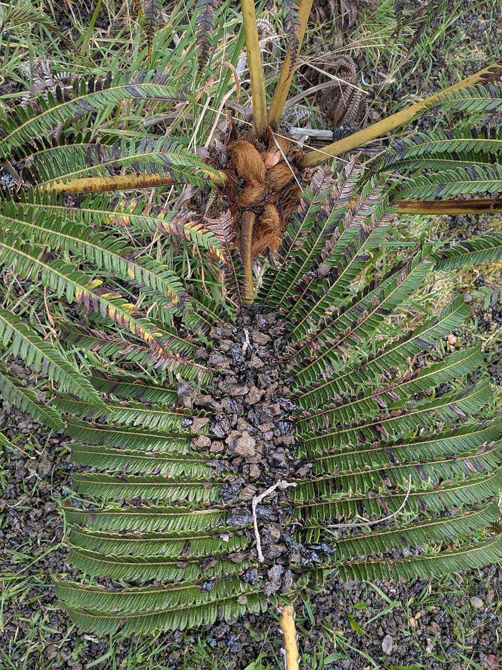
Tephra coating the ground and the plants. Photo by Amy Pallant.

Vog leaving the vent and flowing across the island. Photo by Amy Pallant.
Eventually I found a place to sit and reflect on how much had changed both in the landscape around me and in the students’ learning.
I also thought about what I learned from the students about living on a volcanic island. My mind shuffled through their comments and our experience of Kīlauea. I marveled at how people have come to make sense of Earth’s powerful processes.