After weeks of tracking, prediction, and preparation, we watched Hurricane Isaias run its course and dissipate over northeast Canada. Now that the skies have cleared and the winds have passed, we know all that we can about Hurricane Isaias.
We know that as a disorganized low pressure system moving east across the Atlantic, Isaias quickly strengthened to become a tropical storm. We know Isaias turned northeast after making landfall in the Caribbean, gaining strength as it soaked up the warm tropical waters to become a Category 1 hurricane. We know that millions felt the impact in the United States while it moved along the western edge of Florida and Georgia, dropping six inches of rain in some areas. The storm surge brought on by Isaias caused the third highest high tide ever in Myrtle Beach, South Carolina. And Isaias caused hundreds of power outages throughout the Carolinas and Mid-Atlantic states with its hurricane-force winds knocking down trees and powerlines.
As wind speeds slowed while Isaias traveled over land, the ninth named storm and second hurricane of the 2020 season dropped back down to a tropical storm as it moved to the Northeast states and Canada. Isaias has now come and gone. We have recorded its speeds, path, and other measurable outcomes. These are now in the books. But what did we know before Isaias was even named?
Meteorologists made predictions. When Isaias first formed, no meteorologist could have predicted exactly what was described above. There is no computational model that could have said exactly where, or when, or how strong Isaias would be. In other words, there was always uncertainty in the forecasts. Wrangling with uncertainty, trying to minimize what we don’t—or can’t—know is the hardest part of a meteorologist’s job. To combat uncertainty, scientists use sophisticated models and run many simulations to determine which paths are most likely and estimate the expected impacts for each scenario. They continue to run models as the storm travels. As the storm gets closer, the predictions become more accurate.
The GeoHazard project is focused on developing learning materials exploring natural hazards as well as their predictability, impacts, and risks. GeoHazard developed a five-activity curriculum module to help students wrangle with the uncertainty in hurricane forecasts. Students now have the ability to run hurricane scenarios with Concord Consortium’s new Hurricane Explorer model. Students use the model to learn about the factors that influence the track of a hurricane and the ways in which a hurricane has the potential to impact those in its path.
Students engage in practices similar to those used by scientists by adjusting model variables such as the location and magnitude of pressure systems and sea surface temperature. The model allows for quick and easy experimentation with unlimited configurations of initial conditions. Just as meteorologists seek to understand all possible storm paths, so too can students. The Hurricane Explorer makes it easy to model real-world hurricanes like Isaias, as well (Figure 1).
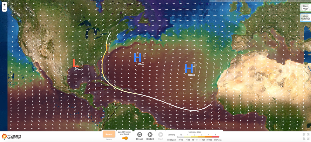
Figure 1. The Hurricane Explorer model showing the path of Hurricane Isaias.
Throughout the curriculum, students use the Hurricane Explorer model to explain and predict how the path and strength of a hurricane can change due to changes in sea surface temperature, the location and magnitude of atmospheric pressure systems, and proximity to land. Students can experiment with the model to see how one small change in the atmospheric conditions can lead to a dramatic shift in the path or intensity of a hurricane.
Additionally, students investigate how uncertainty plays a role in the assessment of risk faced by a community when a hurricane threatens. With the use of street maps, population maps, storm surge hazard maps, and precipitation overlays, students can deeply engage in assessing the impacts of a hurricane. They are able to ask and answer questions that get at the heart of making predictions of impact with uncertainty. For example, how are people impacted if a hurricane hits the inland states vs. the coast?
Throughout the module, students confront what it means to include uncertainty in their analysis. In particular, when exploring Earth systems, which are extremely complex, and atmospheric conditions that are constantly in flux, student reasoning is scaffolded so they consider why even the most sophisticated models cannot simulate exactly where a hurricane will go or how strong it will be. Meteorologists communicate uncertainty in their hurricane forecasts, alongside all that is known. The cone of uncertainty is one example. Helping students understand the sources of uncertainty makes their reasoning more robust.
The Hurricane Module is aligned to the Next Generation Science Standards, and includes pre- and post-assessments, teacher support materials, and a real-time dashboard to help track of student work in traditional classroom settings as well as in a remote learning context.
Hurricane Isaias impacted millions of people in the U.S., Canada, and the Caribbean. While hurricanes remain difficult to predict, especially because they can change suddenly, forecasting has improved due to more sophisticated weather monitoring devices and an increase in computing powers. New dynamic models are better at predicting the probability of future events based on current conditions. Thankfully the forecasts made by meteorologists give people more confidence in knowing where hurricanes are heading and provide them with more opportunities to prepare. Being able to make informed predictions in the face of uncertainty saves countless numbers of lives every year.
Uncertainty is a part of weather forecasting, but by understanding what is known and what uncertainty means, we can be more informed and more prepared for what comes next.
One thought on “Wrangle uncertainty with the Hurricane Explorer module”
Comments are closed.
Guten Tag aus Deutschland, bitte die Möglichkeit mehrere Hurricanes zu setzen und jeweils 1 weiteres Hoch- und Tiefdruckgebiet. Danke