If you think wildfires are in the news more now than in the past, it’s not your imagination. Rather, the increase in wildfires is a trend that scientists have also noticed. One of the many factors driving this change is due to a rise in global temperatures. Because of climate change, droughts are intensifying and fire seasons are getting longer. Scientists are exploring all the factors that influence wildfire behavior and considering the results of experimental computer models with field data.
Up until now, wildfire models have only been available to scientists using supercomputers. Now, with our brand new model, Wildfire Explorer, users can set up experiments with different initial conditions and investigate how the modeled wildfire responds.
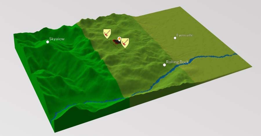
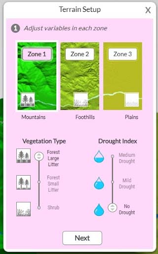
Wildfire Explorer is designed to let students learn about the role different factors play in wildfire spread. The Wildfire Explorer visualization is a zoned landscape composed of mountains, hills, or plains. Through a Terrain Setup wizard, students can experiment by adjusting important factors:
- Choose different landscapes to explore the role of terrain in fire spread. Does fire in the mountains behave the same way as grasslands?
- Explore which vegetation type — varying from grass and shrubs to forests with different ground litter — will provide the best fuel for a fire.
- Experiment with levels of drought and see if dry or damp areas will fuel or slow a wildfire.
- Observe how wind can change a wildfire by adjusting the speed and direction the wind blows.
In the example above, each of the three zones has a marked city or town, giving students a landmark to base their wildfire mitigation around. Wildfire Explorer has two real-life fire-fighting methods for students to experiment with. Firelines, built by firefighters in an attempt to contain fire spread, are simulated in the model by drawing a fire line across the land. Helicopters used to douse areas in water, called helitacks, can be used in the model in hopes of making vegetation too wet to burn. Students have to make quick decisions on which areas are most at risk and where to allocate their resources to fight the fire and protect communities.
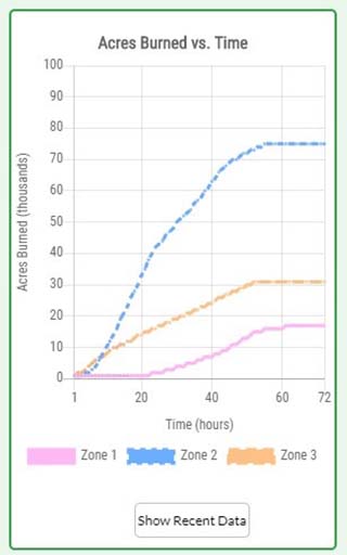
Users place a spark anywhere in the model and watch as the wildfire spreads. A graph is also included, letting students track the number of acres burned in each zone.
The Wildfire Explorer and the soon-to-be-available online wildfire curriculum module will help students understand the risks and impacts of wildfires for our future. By experimenting with extreme drought and other important variables, students will be able to simulate the possibilities that climate change has created and will continue to bring. Assessing the risks and impacts of wildfires in the future is a step in the right direction towards making natural hazards easier to predict in our ever-changing world.
Try the Wildfire Explorer model at learn.concord.org/geo-wildfire!