The GeoHazard team contributed to this blog post.
We have just wrapped up a week of remote professional learning for our GeoHazard: Modeling Natural Hazards and Assessing Risks project. The goal of GeoHazard is to help students interpret data and understand the factors influencing the progression of and risks associated with natural hazards.
Due to the COVID-19 pandemic raging through the United States, the workshop was held completely remotely. We made the decision to hold the workshop remotely in the spring when we had been asked to shelter at home in order to stay safe and “flatten the curve.” We needed to act and react quickly to the situation, so we emailed the teachers who had originally signed up for our face-to-face professional development (PD) workshop:
We simply did not think that a science education professional development focused on helping develop understandings of risk and impact of natural disasters could justify meeting in the midst of a pandemic.
Happily, 29 teachers agreed to participate in a remote learning context.
The decision to move the PD to remote learning made us realize firsthand just how difficult it can be to wrestle with the reasoning and decision-making challenges that involve evaluating the risks and impacts of hazards. There are so many unknowns and great uncertainty. The pandemic provides a unique and timely (though unsettling) lens into what we are asking teachers to do in the upcoming academic year. And our workshop itself became a testing ground for how to think about teaching risk and impact.
We began by asking teachers to think about their own experience of decision-making in the context of the pandemic. By beginning here, with a common experience that is salient to all of us, we help teachers think about and articulate an initial model of their decision process framed in terms of risk and impact.
Like the pandemic, natural hazards from flooding, hurricanes, or wildfires impact millions of people’s lives, which is why we chose these three topics as the focus of our set of GeoHazard modules. Each module explores the underlying variables responsible for turning a natural phenomenon into a human hazard and how to assess risk from the specific hazard.
In the Next Generation Science Standards, ESS3B: Natural Hazards calls for students to explore how natural hazards affect individuals and societies in order to prepare for, and respond to, future natural hazards. When studying risk and impact, students need to consider both the likely occurrence of an event and the likely impact caused by the event, all while noting the great uncertainty related to assessing the risks.
We used our wildfire curriculum module to frame the discussion throughout the workshop. In this module, students use the Wildfire Explorer, a computational model and simulation, to consider individual factors (wind speed, wind direction, vegetation, terrain, and drought conditions) that make wildfires more or less of a risk to people in different communities. The scaffolded module addresses the following learning goals:
- Wildfires become natural hazards when they bring fire and smoke to regions where people live or have various economic, ecological, or societal interests.
- Wildfires cause damages and losses (negative impacts) to humans and the environment.
- Assessing risk involves uncertainty.
- Human actions can increase or decrease short-term and long-term wildfire risks.
Students use Wildfire Explorer to 1) estimate the level of risk for different towns in the model given certain initial conditions; 2) explore ways people might be able to reduce risk; 3) consider how changes in variables change risk; and 4) think about ways people in the communities might be impacted by wildfires.
The video of the model below is one example of how students are asked to estimate the risk to each town if a fire were started at the center of the model.
By comparing the factors that affect the spread of wildfires as well as the specific locations of the communities, students begin to explore how risk is estimated and how slight variations in initial conditions can change the outcome.
During the workshop, teachers explored questions like: How might a student’s perception of risk help them understand what decisions might be made? Are current firefighting tools, such as dropping water from helicopters or building fire lines, enough to stop all fires? How might climate change alter future wildfire risks and impacts?
These are all heady questions. Using models to investigate variable inputs and outcomes can help both teachers and students imagine how various scenarios might play out and affect people in different communities.
After exploring hazards, risks, and impacts within the wildfire module, we circled back to the pandemic models of risk and impact teachers had developed to make connections to what they had been exploring in the GeoHazard module. We asked teachers to use concepts of risk and impact to describe how they behaved with regard to COVID-19 in February and April of 2020, and how they would behave when the new school year is set to open. Teachers worked in groups and described the impacts on behavior, perceived risks, and uncertainties for themselves, their classes, their communities, and the world.
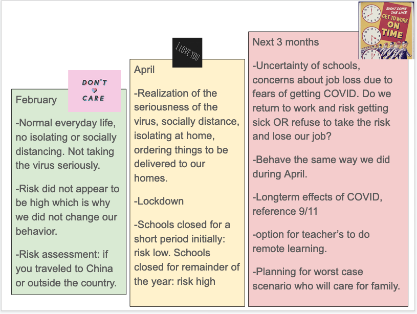
One group of teachers’ responses to behavior with regard to COVID-19 over time.
We hope that our Earth system models can equip teachers with both resources and approaches to help students use models for inquiry as they try to make sense of real-world phenomena, whether it’s the risk of actions or policies related to the current pandemic or the risk of a wildfire affecting homes and lives.
Sign up now for updates when the wildfire module and model are available to the public!