In the last 30 years, the risk of inland flooding in the United States has increased dramatically. Extreme rainfall events have become more frequent, causing widespread flooding and water damage. The costs to repair, rebuild, and remediate flooding have grown each year. Flooding in the Midwest in 2019 alone affected 14 million people and came with a price tag of over $6 billion dollars. Our GeoHazard project has designed and tested an online curriculum module to help middle and high school students investigate the risks and impacts of inland flooding.
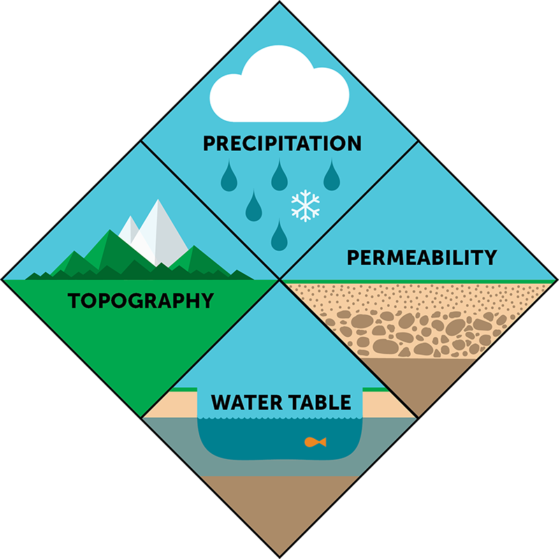
Our new flood module asks students to explore the guiding question, How will flood risks and impacts change over the next 100 years? Students work through a five-activity sequence and investigate the environmental factors that contribute to the severity of river flooding–topography, surface permeability, water table, and precipitation–using an interactive simulation called the Flood Explorer. They are also presented with case studies and real-world data of recent floods in the United States, plus videos, animations, and groundwater simulations. The curriculum focuses not only on the scientific factors that influence floods, but also on the hazards and impacts that floods bring to people living and working in flood-prone areas. By the end of the module, students consider how rising global temperatures and extreme weather events may affect flood risks in the future.
Throughout the one-week unit, students conduct experiments with the Flood Explorer, a map-based simulation that allows students to test the factors that contribute to flooding in a fictitious river community. Students begin their exploration by setting the amount of precipitation, controlling the length of a storm (short, medium, or long), and choosing the amount of rain (light, medium, or heavy) for each simulated flood event. As the Flood Explorer runs, students observe the points along the river where the banks overflow and floodplains are inundated. Simultaneously, students see a graph of the number of acres flooded in the entire region. Using a topographic map overlay, students discover that water always moves downhill and easily spreads in flat, low-lying areas. Students also examine how the river stage changes in a cross-section view of the river at three different locations. This view is especially helpful as students consider how ground saturation can affect flooding.
Using a permeability map overlay, students then investigate rainwater infiltration in urban versus rural areas. Experiments with ground permeability are set around three different maps of the same river community representing the past (Silverton), present (Silver City), and future (Silver Metropolis). By comparing flood events in the Silverton map, composed of undeveloped land and farms, and the modern map of Silver City, students observe how the addition of buildings and roads impedes the ground’s ability to soak up rainwater, resulting in a wider extent of flooding. Finally, students also conduct experiments in the future site of Silver Metropolis. With its massive population growth and development, the city now has many more acres of impervious land, and students explore how urbanization, in conjunction with more extreme rainfall events, impacts the likelihood of flood risks for future residents along the river.
The module is scaffolded with background material, instructions, and question prompts for students. As the students conduct experiments, they answer questions that probe at their understanding of both the scientific and the sociocscientific issues related to flooding. For example, in one task, students place levees along the river to protect specific areas from flood damage such as the hospital, airport, or elementary school. As students learn from a parallel real-world case study, the decision of where to place these levees is complex. While the areas behind the levees may be protected in a flood event, there can also be negative implications for other locations along the river.
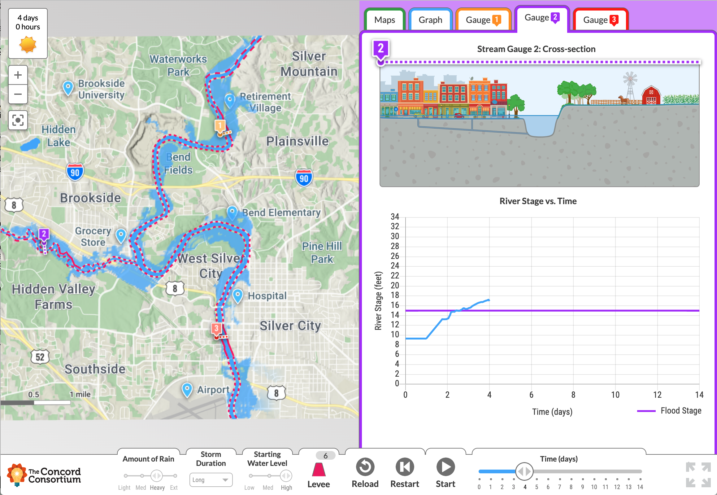
In the Flood Explorer, students set variables and watch the effects on flood events. A graph on the right shows the river stage over time.
This simulation-based task and other activities are grounded in socially relevant problems that ask students to consider the scientific factors that affect flooding, as well as the risks to people and their communities. While the NGSS asks teachers to address the connection between natural phenomena and human activities, there is no framework on how to best teach natural hazards and risks to students. Although natural hazards are becoming more common, many Earth science teachers do not have the necessary content knowledge needed to teach about natural hazards. In addition, many teachers who are confident in their ability to teach the science are still uncomfortable and unprepared to discuss the societal issues that arise when talking about vulnerable populations, risks, and other social ramifications. To address these issues, the flood module’s companion Teacher Edition includes discussion points and tips on leading classroom discussions on socioscientific topics.
All of the flood module resources, including the Flood Explorer, assessments, and teacher support materials, are available at https://learn.concord.org/geo-flood
We would like to thank our partners at Penn State University, TERC, and National Geographic for their contributions to this important resource!
Flood Module Overview
Activity 1: Go with the flow
Students investigate the phenomenon of inland river flooding and are introduced to four key environmental factors that influence flooding. Using the Flood Explorer model, they investigate the first factor, topography. They also begin to examine real-world data on the frequency and extent of flooding in the midwestern part of the United States.
Activity 2: Here comes the flood
Students experiment with the Flood Explorer model to investigate storm duration, amount of rain, and starting water level to see how they influence flood severity. Students also learn about flood warning systems and how stream gauges are used to help predict when and where floods are likely to occur.
Activity 3: Permeability problems
Students use models to explore how permeability affects flooding. They compare flood risks and impacts in areas with different types of land cover (rural, suburban, and urban) and are able to observe differences in the timing and extent of flooding during heavy rainfall.
Activity 4: Flood hazards
Students explore the two main hazards of flooding, inundation and strong currents. They use the Flood Explorer model to consider the impact of these hazards and to investigate mitigation methods to reduce the impact. Students investigate how mitigation methods can have both positive and negative consequences to people living and working along the river.
Activity 5: Future floods
The future of flood risk is complex and is being actively researched by scientists. Students investigate how climate change correlates to projected changes in flood frequency, intensity, risk, and impact. Students model flood occurrence in a future that includes more extensive human development along waterways as well as more frequent and extreme rain events.