My journey started in the mid of July 2018. In two months I have learned how to develop a powerful app from scratch. At the end, the Infrared Street View is coming into sight! This blog article shows some of the (imperfect but promising) results, as demonstrated in Figures 1 and 2.
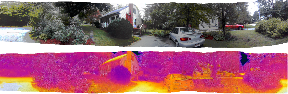 |
| Fig. 1: Panoramas in visible light and infrared light generated by SmartIR |
This milestone is about developing the functionality in the SmartIR app for creating infrared panoramas so that anyone who has a smartphone with an infrared camera attachment such as FLIR ONE could produce a panoramic image and contribute it to the Infrared Street View, much like what you can do with Google’s Street View app. Although this sounds easy at first glance, it has turned out to be quite challenging as we must work under the constraint of a very slow infrared thermal camera that can only take less than ten pictures per second. As our app targets average people who may be interested in science and technology, we must provide an easy-to-do user interface so that the majority of people can do the job without being overwhelmed. Lastly, to create virtual reality in infrared light, we must overcome the challenge of stitching the imperfect thermal images together to produce a seamless panoramic picture. Although they are many image stitchers out there, no one can be sure that they would be applicable to thermal images as those stitchers may have been optimized for only visible light images.
 |
| Fig. 2: Panoramas in visible light and infrared light (two coloring styles) generated by SmartIR |
To support users to make 360° panoramas, SmartIR guides them to aim at the right angles so that the resulting image set can be used for stitching. These images should be evenly distributed in the azimuthal dimension and they should overlap considerably for the stitcher to have a clue about how to knit them together. SmartIR uses the on-board sensors of the smartphone to detect the orientation of the infrared camera. A number of circles are shown on the screen to indicate the orientations which the user should aim the cursor of the camera at. When the cursor is within the circle, an image is automatically taken and stored in a 360° scroller. By turning at a fixed position and aiming at the circles, the user can capture a series of images for stitching. The following YouTube videos show how this image collector works.
Although this is a very primitive prototype, it nonetheless represents the first concrete step towards the realization of the Infrared Street View. Down the road, stitchers for infrared thermal images still need significant improvements to truly achieve seamless effects similar to those for visible light images. Tremendous challenges for weaving the Map of Temperature still lie ahead. I will keep folks posted as I inch towards the goal and I am quite optimistic that I can get somewhere, even though I am not a Googler.