 |
| Figure 1. Global insolation pattern from Pole to Pole |
The Sun’s power drives the climate of the Earth. Accurately modeling the incident solar radiation, namely, insolation, at a given location is important to the design of high-performance buildings. As I have blogged last week, the insolation calculation in our Energy3D software considers the incident angle of the Sun to the surface, the duration of the day, and the air mass. And we have recently incorporated the effect of altitude and the ambient inputs.
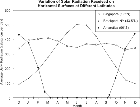 |
| Figure 2. Real data for the three locations (source) |
In Energy3D, we can easily investigate the global pattern of insolation by horizontally placing a sensor module on the ground and then collecting the sensor data throughout the year. We can easily change the latitude and collect a new set of data. Figure 1 shows the global insolation pattern from the North Pole to the South Pole. The time integral of each curve represents the total solar energy a location at the corresponding latitude receives. There is an interesting observation from Figure 1: The Equator doesn’t actually have the highest peak value and its peak values are not in the summer but in the spring and fall. However, because the insolation does not differ very much from season to season in the Equator, its time integral is much larger, which is the Equator is hot all year round.
 |
| Figure 3. Energy3D’s prediction |
How accurate are the predictions of Energy3D? Let’s pick three locations that someone has collected real data, as shown in Figure 2. More insolation data can be found on this website. (Surprisingly, the peak solar energy at the South Pole is higher than the peak solar energy at the Equator.)
Figure 3 shows that the insolation values predicted by Energy3D. As you can see, the predicted trend agrees reasonably well with the trend in the real data. Overall, Energy3D tends to underestimate the insolation by about 50% (after unit conversion), however.