Visualizing Geohazards and Risk with Code
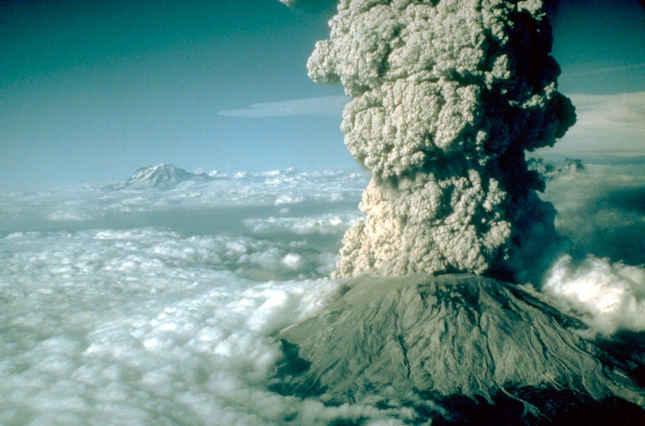
When the 1992 Cerro Negro volcano in Nicaragua erupted, it released billions of kilograms of tephra—fine particles of ejected rock—over the course of two days. People living near the volcano were affected by this mighty display of power. The tephra and magma that were ejected by the volcano damaged buildings, contaminated water supplies, destroyed plants, hurt animals, and caused human health hazards. Despite widespread damage, the Cerro Negro volcano is considered a fairly small eruption. In more recent years, much larger volcanic eruptions in Alaska and Iceland have disrupted aviation and posed health risks for people living even farther from the volcanic sources. In December 2019, the volcanic island of Whakaari in New Zealand erupted, killing 19 tourists, reminding us that even small eruptions can have fatal consequences.
To understand such potential risks, scientists who study active volcanoes like Cerro Negro look at factors that influence how tephra travels and where it may land. They dig pits in past eruption locations to discover the volume and distribution of tephra and draw maps of where the tephra fell. Geoscientists use these observations of past eruptions to create models, using them to predict the impacts of future explosions. By understanding the mechanisms that cause such geohazards, scientists can consider the potential impacts and dangers. Their work also helps citizens understand their community’s vulnerability and exposure to imminent risk.
Data fluency in scientific practice
Our Visualizing Geohazards and Risk with Code (GeoCode) project was developed in response to the National Science Foundation’s STEM+C challenge to develop computational literacy in U.S. schools. The C stands for computing, and the program recognizes that current scientific and engineering disciplines require integrated computational literacy. The goal of the GeoCode project is to help high school students understand, construct, interpret, and revise computational visualizations so they can explain scientific phenomena and make predictions about the probability of risks. Our pedagogical model combines scientific inquiry and computational thinking in a way that mirrors geoscientists’ modeling of geohazards.
Students focus first and foremost on the phenomenon of volcanoes, the geologic conditions that cause them, and the risks they pose. Volcanologists at the University of South Florida have helped us frame our curriculum so that it engages students in computational practices that closely match the methods they use in their research. By introducing computation into the geology curriculum, we are giving students tools to facilitate authentic experiments that address the hazards and risks to people living near volcanoes. We expect that students will also develop an instinct for identifying problems outside of geoscience that are also amenable to computational approaches.
GeoCode Explorer
Our GeoCode Explorer programming environment challenges students to model tephra impact by applying the practices utilized by volcanologists. We use a visual block programming language called Blockly to provide a simple but robust coding workspace that doesn’t overwhelm students, since the principal goal is to learn about volcanoes. We integrated Blockly into a simulation environment that includes a tephra distribution model built by our partners at the University of South Florida, and added a suite of custom blocks that provide access to data, graphs, charts, and maps (Figure 1).
Students learn about the Cerro Negro volcano by using GeoCode Explorer to isolate different variables that contribute to tephra fallout patterns. The two-week curriculum gradually introduces computational practices, such as problem decomposition, conditional expressions, and looping, while asking students to explore more complicated questions. Which towns are likely to be affected by fallout if the wind is blowing out of the east? Using historical records, how likely will the wind be blowing in that direction on any given day in October?
Initially, students manipulate sliders that change the input parameters of the simulation one at a time. For example, they observe how the wind direction impacts the amount of tephra that lands on a nearby town. Next they examine how the eruption volume impacts the neighboring communities. Throughout the activity, we introduce students to increasingly sophisticated programming blocks. Students learn about “variables” as both a scientific idea and a programming construct. Similarly, students build programs that repeat experiments while systematically changing and constraining variables. These loops and variables are a cornerstone of computer programming and ultimately speed up analysis.

Monte Carlo simulations to assess risk
Despite the hazards of volcanoes, many people live near them and know that an eruption could happen at any time. Tephra is particularly destructive and poses many risks to these communities. The job of scientists is to assess the environmental risks of future eruptions and communicate these to affected communities.
Using historical wind records and tephra distribution data from past volcanic eruptions, volcanologists can produce accurate assessments and maps by running thousands of computer simulations. This general approach is known as the Monte Carlo method, which describes a range of computational algorithms that use random data sampling to obtain probabilistic results. Input parameters are selected from an enormous set of observations—the more random samples that are drawn, the higher the confidence in the distribution of outcomes. This approach is decidedly computational because it leverages the speed and data processing capabilities that computers provide.
At the end of the GeoCode module, students produce their own risk assessment maps. Given a map with a volcano and nearby school, students should be able to answer questions such as “How likely is it that the next time this volcano erupts, the school’s roof will collapse?”
One way to answer such questions is by using a simplified version of the Monte Carlo approach favored by volcanologists. The prospect of running a thousand simulations required by this approach would not usually occur to students. To consider this, they must have a computational instinct, knowing that computers can easily facilitate jobs that involve repetition and variable substitution. Can we help students build those instincts?

A 21st century literacy
While language arts and mathematics were the foundational skills of the 20th century, computational literacy is critical for the 21st century. Computers are ubiquitous in the workplace, regardless of the industry. Scientific research, in particular, will require increased facility in the use of machines and algorithms to make sense of the petabytes of available data across all scientific disciplines. Indeed, today’s scientists and academics are foregrounding the computational nature of their work by publishing not only their research findings, but also the data and algorithms they used in their research via interactive lab books written in R or Python, for example.
Now more than ever, authentic inquiry-driven experiences require proficiency with data and data processing tools, as well as the computational thinking skills to construct explanations and design solutions. The GeoCode project aims to equip students with a deep awareness of computation and provide them contextualized opportunities to flex their data sleuthing muscles.
Noah Paessel (npaessel@concord.org) is a senior software engineer.
Photo credit: Jim Valance, Cascades Volcano Observatory, U.S. Geological Survey
This material is based upon work supported by the National Science Foundation under grant DRL-1841928. Any opinions, findings, and conclusions or recommendations expressed in this material are those of the author(s) and do not necessarily reflect the views of the National Science Foundation.