Seismic Shifts in Supporting Teachers in Earth Science Classrooms
Plate tectonics in secondary school is rarely treated as an investigatory science as it does not lend itself well to laboratory experiments—students cannot wait millions of years for the results of an experiment. Changing how Earth systems thinking is taught is going to take a seismic shift.
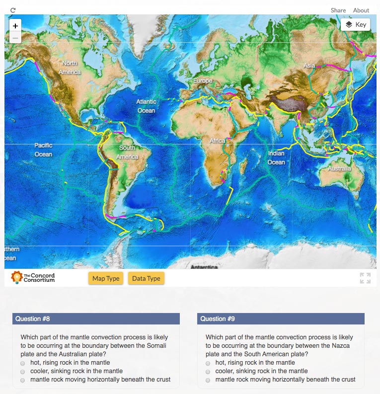
To address this challenge, our GEODE project developed an inquiry-based systems approach to plate tectonics around the driving question: “What will Earth look like in 500 million years?” This plate tectonics module represents a fundamentally new way to teach the topic, turning geosciences on its head. In the curriculum module, students use our new Tectonic Explorer and Seismic Explorer models to understand that Earth’s surface is a dynamic system in constant motion and to discover the causal mechanism responsible for the landforms and geologic events found on Earth.
But the module can’t do it all. The teacher plays an important role as a facilitator, helping students evolve their understanding by guiding discussions, eliciting new ideas, and making sense of the multiple representations provided within the curriculum. Supporting teachers is essential as they make this shift in how plate tectonics is taught.
Summer teacher workshops have been the cornerstone of our professional development strategy for years. Dedicated teachers have met with us for days to learn about our research projects, dive deeply into both science content and pedagogy, explore our dynamic models, and learn how to teach with an online curriculum. We love meeting with enthusiastic teachers and developing a shared camaraderie, but face-to-face workshops include only a small number of teachers. Transforming Earth science education requires ambitious goals: we want to reach many more Earth science teachers so that we can explain the background and theory that led to the development of our innovative models and curriculum, share the pedagogies that work in real classrooms, and provide practical teaching tips, extensions, and other tools for success.
We set out to do that by developing the next generation of freely available just-in-time online teacher support materials that can be used as teachers both prepare for and implement the plate tectonics curriculum in their classrooms. This interactive online teacher guide was designed as part of the GEODE project.
Scaffolded interactive materials
Rather than offering a curriculum module for students and a separate teacher guide or online course for teachers, we have integrated educational materials for teachers directly into the student materials. We designed and developed an interactive Teacher Edition, where teachers learn both how to use the module and how to teach with it—in the same context as their students. The Teacher Edition adds a layer of background information and teacher tips on top of the Tectonic Explorer and Seismic Explorer models, case studies, and real-world data presented to students. The Teacher Edition allows teachers to use the curriculum wearing both student and teacher hats at the same time. We have observed in face-to-face workshops that giving teachers ample time to use the module and explore the models helped them feel comfortable, confident, and prepared to use the curriculum in their classroom.
Unique curriculum design
The Teacher Edition also gives teachers insight into the decisions we made in developing the Tectonic Explorer and Seismic Explorer models, as well as the overall curriculum. The plate tectonics module was carefully choreographed to reveal important concepts organically over the course of a five-activity sequence. The activities are designed around real-world case studies of convergent, divergent, and transform boundaries. Students look at distinctive landforms such as the Andes Mountains, the Aleutian Islands, and the Himalayas by analyzing geographic profiles and associated earthquake and volcano data. Students work with parallel representations across visualizations, including three-dimensional cross-section views, to help anchor their thinking.
Teachers are integral to helping students make connections between the models and real-world data, supporting them as they work like geoscientists, applying what they have learned about Earth’s plate system to puzzle out different case studies on Earth. Drawing upon what they already learned about how Earth system processes created and continue to shape the landforms on Earth’s surface, students are able to use real-world plate motion data to make predictions about what Earth might look like in the future.
Supporting model use
Seismic Explorer and Tectonic Explorer make the invisible visible. Because these models are complex and take a systems thinking approach, teacher training on how to assist students in their use is critical. The Teacher Edition provides background and tips on how to use these models, enabling teachers to guide their students in experimentation and construction of evidence-based explanations of phenomena. We include how-to videos on specific model features (e.g., how to create force vectors on individual plates in Tectonic Explorer), as well as pedagogical strategies on how to best engage students in using and making sense of multiple representations. When new parts of Seismic Explorer and Tectonic Explorer are introduced, we explain many of the design decisions that went into that model, what variables we left in, what we left out, and why.
Evolving student understanding
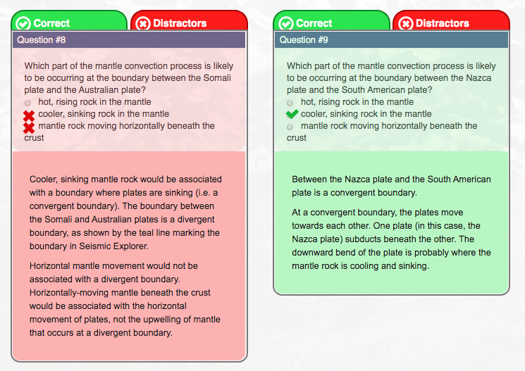
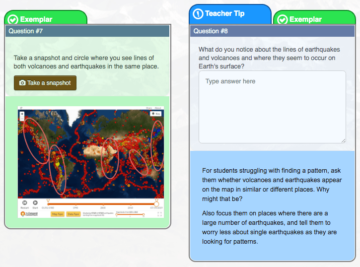
An important feature of the Teacher Edition focuses on giving teachers insight into student responses to the questions embedded in the plate tectonics module. Using the Teacher Edition, teachers can answer the questions just like their students. The Teacher Edition also offers exemplar answers to free response questions and explanations of multiple-choice questions covering both correct answers and distractors (Figures 1 and 2). Using our knowledge of learning progressions and student misconceptions, we are able to help teachers interpret student responses, detect misunderstandings, and offer suggestions. Teachers can look for evidence of student understanding in their written responses. We also encourage student discourse and strategically place discussion prompts at specific points in the curriculum, giving teachers pre-determined places to stop the class and engage students in either whole-class or smaller group discussions.


Extending the curriculum
Throughout the plate tectonics module, case studies and real-world data help scaffold and extend the curriculum. Each of these elements, including data tables, charts, videos, and graphics, are enhanced with tips for teachers that provide instructional resources and methods that teachers may find useful as they help their students achieve the learning goals. The Teacher Edition also provides extension resources for students who are ready to dig deeper into the material. Each tip type includes text explanations, images, and videos, as well as links to primary source data.
What’s next?
The goal of the Teacher Edition is to explain our approach to inquiry-based learning and make our intentions for the design and use of the models and curriculum explicit. We hope that by using these resources and scaffolds, teachers will be able to help their students reach a more robust level of understanding of complex Earth systems. To encourage the essential shift in Earth science education, we are developing Teacher Editions for additional curriculum modules in our GeoHazard and GeoCode projects, so more teachers and students experience Earth science as an exciting lab-based science where investigation and sensemaking are critical for understanding the complex Earth we live on.
Trudi Lord (tlord@concord.org) is a senior project manager.
This material is based upon work supported by the National Science Foundation under grant DRL-1621176. Any opinions, findings, and conclusions or recommendations expressed in this material are those of the author(s) and do not necessarily reflect the views of the National Science Foundation.
