Doing Geosciences the Way Scientists Do
We live on an amazingly dynamic planet. All the landforms around us—mountains, oceans, rivers, deserts, and even continents—are moving, shifting, and reconfiguring themselves in a massive ballet of rock and water. Where and how we live on the surface of our planet is determined by the interactions of Earth’s plates over millions of years. Although many people think that mountains, valleys, and other landforms are static parts of our environment, these are active phenomena, though they are too large and too slow to be easily observed. It all happens at such massive scales of time and space that we see only brief snapshots of this dynamism in the form of events like earthquakes and volcanic eruptions. These invisible geoscience phenomena often significantly impact human lives.
Central to understanding geoscience phenomena, plate tectonics is the foundational paradigm and a key disciplinary core idea in the Next Generation Science Standards (NGSS) in Earth and Space Sciences. It is critical for students to understand how our Earth functions as a system of interacting tectonic plates and to understand the underlying causal mechanisms that drive that system in order to confront challenges such as managing resources, including oil, gas, metals, and sand, as well as preparing and hardening our cities to mitigate catastrophic disasters caused by earthquakes or volcanic eruptions. To address these challenges, we need to prepare students to understand plate tectonics and related disciplinary core ideas, and to reason with representations of large datasets and models that geoscientists use to investigate these astonishingly large-scale phenomena.
NGSS also emphasizes science and engineering practices. These practices (e.g., Developing and Using Models) are meant to apply to all areas of science, but the standards do not clearly articulate subtle differences between the way physicists, chemists, biologists, and geoscientists do their work. Because there is only one Earth and we cannot run experiments with it, geosciences are more observational and historical. Geoscientists examine phenomena by representing large observational datasets (e.g., earthquake epicenters) and by creating models that can be used to test assumptions and explanations against these datasets. Although one may not typically consider such activities as laboratory experiences in school science, they are indeed the epistemically authentic practices of the geosciences that students need to engage in if they are to understand how we know what we know about Earth and the mechanisms that explain how Earth works.
Earth system understanding
Research on learning progressions about plate tectonics informs us that not only do students struggle to develop system understandings of Earth, they also develop misunderstandings about both plate motion as well as the causes of plate motion based on typical approaches to teaching.1 To address these findings, we have designed two computational models that can help students engage with geoscience phenomena in ways that are more authentic to a geoscientist’s investigatory practices.
The Geological Models for Explorations of Dynamic Earth (GEODE) project has developed Seismic Explorer and Tectonic Explorer, along with a related web-based curriculum around them, which support students in developing their own explanations about the dynamic plate system on Earth. Students investigate patterns of topography and the patterns of earthquakes and volcanic eruptions around Earth and develop hypotheses regarding movement along plate boundaries that might explain these and other phenomena.
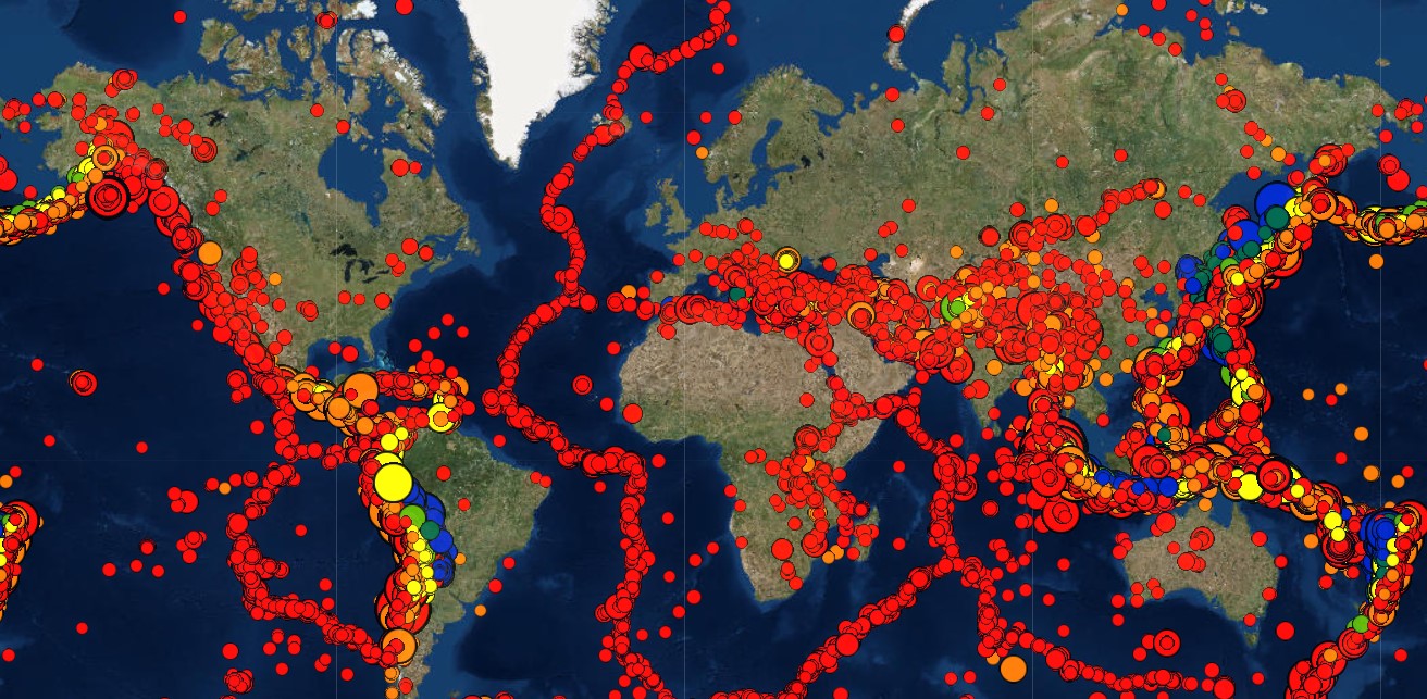
Seismic Explorer is a visualization designed to help students investigate patterns in real-world earthquake and volcanic data across the surface of Earth (Figure 1). Incorporating real-time data from the U.S. Geological Survey, Seismic Explorer displays earthquake locations, magnitude, and depth using dots of different size and color. From this data, students can see lines of earthquakes that define plate boundaries and examine how these patterns of earthquakes relate to continents and other surface features like mountains. Additionally, students can overlay volcanic data from the Smithsonian Institution Global Volcanism Program to see how earthquakes and volcanic eruption patterns occur in the same areas on Earth’s surface, providing more evidence for plate boundaries. With Seismic Explorer’s three-dimensional cross-section tool students can examine patterns of earthquakes beneath the surface of any place on Earth (Figure 2). They can also ask questions about the differences between subduction and divergence of plates, and the kinds of characteristic features and events that each of these boundaries produce. The goal of Seismic Explorer is to allow students to develop claims about patterns they see in large geological datasets and to propose initial explanations of these patterns.


Tectonic Explorer is a simulation of an Earth-like planet designed to provide students with a model of a dynamic plate system for testing the hypotheses they developed in Seismic Explorer. With Tectonic Explorer students can design the simulation with different numbers of plates, draw continents on different parts of the surface, set the direction of plate movement with force vectors, and determine the relative density of plates, which affects which plate subducts at a boundary (Figure 3). They can run the simulation multiple times to test different aspects of the model’s output. For example, they can examine in detail the model of an oceanic plate as it is subducted beneath a continental plate and forms mountains, as well as see how volcanoes form inland from the boundary. A cross-section tool allows students to see what is happening below the surface at the boundaries where plates interact.

Tectonic Explorer and Seismic Explorer are embedded into a curriculum built around explaining the phenomenon of plate motion represented by GPS data and the historic model of the movement of continents. Students engage in a series of exploratory case studies of different parts of the globe that represent key boundary types and how they create specific features and events. They examine their thinking about the origin of the patterns in data from Seismic Explorer, then use Tectonic Explorer to help them understand the complex phenomena associated with plate tectonics. Using a claims, evidence, and reasoning framework, as well as asking students to think about the inherent uncertainty of the models and their claims, the curriculum creates an investigatory context for geoscience phenomena that represents a novel approach to teaching plate tectonics.
GEODE is exemplary of an approach to geoscience learning that not only helps students develop understandings of the foundational big idea of plate tectonics, but also helps them experience Earth and space science as an investigatory science. The design was informed by ambitious science teaching practices to help students develop initial explanations.2 By giving students a context that is an epistemically authentic approximation of geoscience practices to understand large-scale and systems-level phenomena, GEODE helps students learn geoscience content and practices and expands their notions of what science practices look like.
Scott McDonald (smcdonald@psu.edu) is Associate Professor of Science Education at Pennsylvania State University.
1. McDonald, S., Bateman, K., Gall, H., Tanis-Ozcelik, A., Webb, A., & Furman, T. (2019). Mapping the increasing sophistication of students’ understandings of plate tectonics: A learning progressions approach. Journal of Geoscience Education, 67(1), 83–96.
2. Windschitl, M., Thompson, J. J., & Braaten, M. L. (2018). Ambitious science teaching. Cambridge, MA: Harvard Education Press.
This material is based upon work supported by the National Science Foundation under grant DRL-1621176. Any opinions, findings, and conclusions or recommendations expressed in this material are those of the author(s) and do not necessarily reflect the views of the National Science Foundation.