Developing Watershed Stewards
Everyone lives in a watershed, which makes us all watershed stewards. The Teaching Environmental Sustainability: Model My Watershed project—a collaboration funded by the National Science Foundation between the Concord Consortium, Millersville University, and Stroud Water Research Center—has developed a weeklong curriculum unit to help high school students understand the impact of human actions on the watershed. The curriculum incorporates innovative technologies that provide students with access to real data and real tools in actual places to make authentic decisions.
Students explore and evaluate local watershed conditions using probeware, simulations, and a scientifically valid online watershed modeling application. They simulate runoff from a storm event, collect data from their schoolyard, analyze local data from national databases, and model changes in land cover and conservation practices. Finally, they create scenarios to improve their local watersheds.
Probes and simulations for student learning
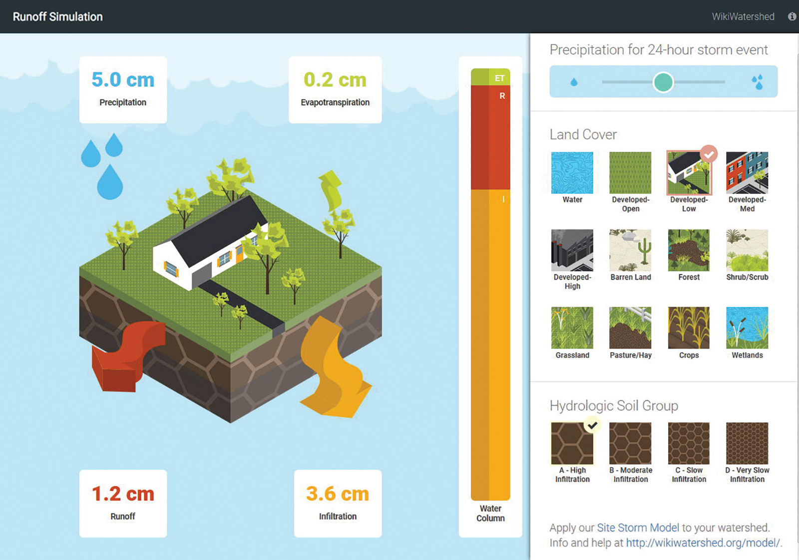
Using the animated Runoff Simulation, students learn how different types of land cover and hydrologic soils influence the distribution of evapotranspiration, runoff, and infiltration amounts after a 24-hour storm event. Students can see the effect of changes they make to variables in the model for different precipitation levels, 12 choices of land cover (from highly developed to wetlands, grassland, crops, and more), and four types of soil (Figure 1).

Students also collect data using low-cost environmental monitoring devices from Texas Instruments called SensorTags, which act as watershed trackers on their smartphones or mobile devices. With these Bluetooth-enabled devices, students collect relative humidity, temperature, and light measurements in different areas, and upload their sensor data to the Innovative Technology in Science Inquiry (ITSI) portal, where the data can be viewed in graphical form, saved in snapshots, and shared with other students and teachers.

For example, to examine the ways in which vegetation and land cover affect the water that evaporates or is taken up by the plants, students might compare an area with one conservation practice such as a rain garden with another area such as a grassy playground without a planned conservation practice. This helps them identify the evapotranspiration from areas where runoff would be greater. Students use small stakes or markers to identify the four corners and center of two nine-square-meter study sites. At each site’s five marked locations, students hang or tape a SensorTag on a stick one meter above the ground. They then enter the resulting data into the ITSI portal, and an average reading is calculated for each study site for temperature, relative humidity, and light (Figure 2).
After the sensor data is collected, students compare their study sites’ data and discuss how sites that are porous and have high infiltration rates are different from those that are impervious and have high runoff rates. The sites with a large amount of vegetation will have high infiltration and evapotranspiration rates.
In the final activity of the curriculum unit, students use a scientific modeling tool called Model My Watershed (MMW) to create scenarios for improving their local watershed. MMW is a watershed-modeling web geographic information systems (GIS) app that includes USGS, USDA, and other scientific datasets for watershed modeling across the entire lower 48 states.

It enables citizens, conservation practitioners, municipal decision-makers, educators, and students to analyze real land use, soil, and additional data in their neighborhoods and watersheds; model stormwater runoff and water quality impacts using professional-grade models; and compare how different conservation or development scenarios could impact runoff and water quality.
Using MMW, students select an area of study and analyze watershed data for that site. By running the site storm model of a 24-hour storm event, they can view the runoff and water quality results under current conditions (Figure 3). Next, students create scenarios to model changes in land cover types and conservation practices using the same 12 land cover choices in the Runoff Simulation, along with six conservation practice choices. Students can view multiple scenarios side-by-side to compare results (Figure 4).

Making activities relevant to local contexts
The curriculum unit was designed for students to learn systems thinking and geospatial analysis skills in the context of place-based watershed science problem solving. It includes five activities that can be easily customized in the ITSI portal. Teachers can modify activities and tailor them to their instructional objectives, student abilities and prior knowledge, and school context. For instance, teachers can include a discussion or activity to introduce their students to foundational understandings of watershed concepts. An extensive teacher’s guide includes vocabulary for the unit.
Authentic data motivates students to take action
The barrier between students’ conceptual understanding of watershed content and their real-world actions can be bridged by providing students with access to scientific tools and authentic data to make informed decisions about their local watershed. Focusing on the students’ “home turf ” provides context and relevance that enhances engagement and promotes meaningful learning.
Our research with 37 teachers and 1,546 students in 7 states shows that MMW students made statistically significant gains in their knowledge of actions that can improve the health of their watersheds. Many students identified actions that can positively impact their watershed such as installing a rain barrel, creating a backyard habitat, and taking care of a stream.
“My neighborhood and I can build a rain garden at the end of our street and the street is slanted so all the run off water runs down there then into the river. If we put a rain garden there we can stop all the trash that the water picks up on the way down to the river and we would have a healthy watershed if everyone helps out.” ~ Grade 7, Colorado
“We can implement porous paving in various areas in my neighborhood to reduce the amount of run off water. Right now a lot of water goes straight into the streets and is being wasted when we could be using porous pavings or rain gardens to reduce that amount.” ~ Grade 7, Colorado
“I am really interested in adding a rain garden or vegetated infiltration basin to my house. It would be helping my watershed by cleaning and allowing the runoff (that possibly carries pollution) to get infiltrated into the ground.” ~ Grade 12, California
The Teaching Environmental Sustainability: Model My Watershed curriculum helps students take on the critical roles of responsible citizens and watershed stewards.
Nanette Dietrich (Nanette.Marcum-Dietrich@millersville.edu) is a professor at Millersville University of Pennsylvania.
Steve Kerlin (skerlin@stroudcenter.org) is the director of education at Stroud Water Research Center.
Carolyn Staudt (cstaudt@concord.org) is a senior scientist at the Concord Consortium.
This material is based upon work supported by the National Science Foundation under grant DRL-1417722. Any opinions, findings, and conclusions or recommendations expressed in this material are those of the author(s) and do not necessarily reflect the views of the National Science Foundation.